Section 5-Outdated
Field Collection of Soil and Sediment Samples
Interim Final – August, 2016
Section 5.0 Introduction
Section 5.1 Initial Site Inspection
5.1.1 Decision Unit Designation
5.1.2 Surface Conditions
5.1.3 Subsurface Conditions
Section 5.2 Site Preparation
5.2.1 Surface Clearing of Debris and Vegetation
5.2.2 Subsurface Utility Clearance
5.2.2.1 Information Gathering
5.2.2.2 One Call Center Notification
5.2.2.3 Field Evaluation of Potential Subsurface Features
5.2.2.4 Subsurface Survey Methods
Section 5.3 Surface Soil Sample Collection
5.3.1 Soft, Fine-to Course-Grained Soils
5.3.2 Moderately Compact, Fine-Grained Soils
5.3.3 Very Compact and/or Gravelly Soils
Section 5.4 Subsurface Soil Sample Collection
5.4.1 Direct Push Technologies
5.4.2 Borehole Core Increment Subsample
5.4.3 Pit or Trench Sample Collection
5.4.4 Hollow Stem Auger Drilling
5.4.5 Rotary Drilling
Section 5.5 Collection of Samples from Stockpiles
Section 5.6 Collection of Multi Increment Samples for VOC Analysis
5.6.1 Increment Collection
5.6.2 Subsurface DU Layers
5.6.3 Alternative Approaches
Section 5.7 Sediment Sampling
5.7.1 Sediment Sampling Equipment
Section 5.8 Field Documentation
5.8.1 Surface Soil Sampling Logs
5.8.2 Subsurface Soil Sampling/Boring Logs
5.8.3 Soil Description
5.8.3.1 Recommended Parameters for Soil Descriptions
5.8.3.2 Example Soil Descriptions
5.8.4 Additional Sample Information
Section 5.9 Equipment Preparation / Decontamination
Section 5.10 Investigation Derived Waste
Section 5.11 Field Work Completion
Figures
5-1 Large Equipment Interfering with Access to a DU Targeted for MI Sample Collection
5-2 Clearing of Thick Grass from a Targeted DU Prior to the Collection of MI Sample Increments
5-3 Bulldozer used to Cut Access Paths and Clear 59 Lot-size (5,000 ft2) DUs within a 500-Acre Field4
5-4 Path Matching Increment Grid Locations Cut Through Thick Vegetation Covering a 50-acre DU; Increment Locations Pre-staked to Expedite Sample Collection
5-5 Field Indicators of Underground Features
5-6 Subsurface Survey to Identify Underground Features
5-7 Various Soil Coring Sampling Tools
5-8 Collection of Increments with a Sampling Tube
5-9 Foot-operated Core Sampling Device Developed by the US Army Corps of Engineers
5-10 Flat Bottom Scoops to Collect Soil Increments from Very Loose Soil.
5-11 Use of Cordless Drill for Sample Collection
5-12 Comparison of Auger Bit Designs
5-13 High-Powered Drill and Portable Generator
5-14 Use of a Slide Hammer to Collect Soil Increments
5-15 Use of an Electric Hammer and Spade Bit
5-16 Collection of Increments Soil Loosened by a Spade Bit or Heavy Duty Hand Tool
5-17 Heavy Duty Hand Tools
5-18 Tunnel Bit Use to Cut Through Asphalt or Concrete and Access Soil
5-19 Direct Push Drill Rigs
5-20 Drilling Rods for a Direct Push Drill Rig
5-21 Split Spoon Sampler
5-22 Continuous Cores Collected using a Push Rig
5-23 Identifying Targeted DU Layers in Cores
5-24 Subsampling of Core Increments for Preparation of a Bulk Multi Increment Sample
5-25 Use of Shallow Pits to Collect Increments from Multiple Layers within a DU
5-26 Example Use of Trenches for Site Investigation
5-27 Use of Shallow Trenches to Collect Multi Increment Samples from Exposed DU Layers
5-28 Hollow-Stem Auger Drill Rig
5-29 Auger Drill Bit and Drill String
5-30 Large Truck-Mounted Drilling Rig
5-31 Pressurized Air Discharge from an Air Rotary Assembly
5-32 Example Recovered Cores and Rotary Drill Coring Bits
5-33 Collection of Increments and Multi Increment Samples from a Flattened Stockpile
5-34 Examples of Opportunities to Collect Increments and Bulk Multi Increment Samples during Stockpile Formation or Movement
5-35 Progressive Testing of DUs from an Unflattened Stockpile
5-36 Subsampling DU Layer Increments from Borehole Cores with Methanol Preservation
5-37 Sediment Sampling Tube
5-38 Collection of Sediment Increments from a Drainage Canal
5-39 Alternative Scoop-Shaped Samplers for Thin Sediment Layers
5-40 Collection of Multi Increment Sediment Increments from a Drainage Canal
5-41 DU Designation and Collection of Multi Increment Samples from a Sugar Mill Drainage Canal
5-42 Use of Core Sampling Device to Collect Sediment Increments
5-43 Removal of Sediment Core Increments from Sampling Tubes
5-44 Field Subsampling of a Sediment Multi Increment Bulk Sample
5-45 Use of a Vibracore Device to Collect Sediment Samples in Deep Water
5-46 Removal of Core Increment from Vibracore Sampling Tube and Subsampling
5-47 Example Surface Soil Sample Log
5-48 Demarcation of Decision Units and DU Information Using a Google Earth Image
5-49 Example Log for Exploratory Borings or Borings Used for the Installation of Wells
5-50 USCS Soil Classification Scheme (after ASTM 2006d)
5-51 Triple Wash Decontamination of Sampling Equipment
Tables
5-1 Overall Performance Estimation for Various Types of Drilling/Excavation Methods
5-2 Relative Performance of Commonly Utilized Drilling/Excavation Methods Versus Commonly Encountered Substrate
5-3 Measuring Soil Density with Standard Penetration Test and Modified California Sampler – Sands, Gravels
5-4 Measuring Soil Density with a Standard and California Sampler – Fine Grained Cohesive Soil
Return to the Top of the Page
5.0 FIELD COLLECTION OF SOIL AND SEDIMENT SAMPLES
This Section describes procedures, methods, and equipment for the collection of Multi Increment soil and sediment samples (refer to Section 4). Alternative sampling approaches, including discrete sampling, must be demonstrated to the HDOH Hazard Evaluation and Emergency Response Office (HEER Office) to meet sampling theory requirements and yield reproducible data in both the field and the laboratory if they are to be used for final decision making purposes (e.g., USEPA, 1995b; USACE, 1996; NJDEP, 2005; Nielsen, 2006; see Subsection 4.3).
A site-specific Sampling and Analysis Plan (SAP) and associated Quality Assurance Project Plan (QAPP) should be developed prior to mobilization for sample collection (see Section 3). The SAP describes the types and quantities of samples to be collected and the rationale for their collection. The plan also describes Quality Assurance/Quality Control (QA/QC) procedures to ensure that sampling design and measurement errors are controlled sufficiently to meet the tolerable decision error rates specified in the DQOs.
Individuals planning or conducting site investigations are encouraged to communicate with the HEER Office regarding the guidelines during all stages of investigation to discuss issues such as:
- Appropriate decisions, data needs, DQOs;
- Aligning sampling strategy with investigation data needs;
- Deviation from sample collection procedures presented in the HEER TGM (e.g. alternative test methods);
- Deviation from approved sample collection methods due to unexpected conditions encountered in the field; and
- Use of technologies or methods not covered in this guidance.
The sampling guidelines presented in this Section are intended to ensure that sample integrity is maintained by capturing and preserving site representativeness to the greatest extent possible.
The HEER Office has developed the process of Fast Track Cleanup (FTC) as an investigation option. For eligible sites, the FTC approach requires less intermediate regulatory review and approval of formal sampling plans by involving increased communication and consultation with the HEER Office. It places a greater burden of technical justification on the FTC participant to demonstrate to the HEER Office prior to conducting an investigation that the chosen sampling strategy will adequately address needs based on site-specific DQO and that proper QA/QC will be performed. If the HEER Office does not believe the quality of work will meet the needs of that investigation, a greater degree of planning and coordination (which may involve submittal of a formal work plan) will be required or disqualify the participant from an FTC agreement. This places responsibility on the FTC participant to hire a knowledgeable consultant who understands the current laws and guidelines. Specific details of the FTC process are presented in Section 15.
5.1 INITIAL SITE INSPECTION
A site visit is imperative to evaluate conditions that might influence the design and implementation of the Sampling and Analysis Plan. Historic site information and data are compiled and reviewed during the first and second steps of Systematic Planning of the site investigation (see Section 3). This information is used to identify potential areas of concern and designate initial DU areas for sample collection.
Finalization of the location, area, and depth of final DUs is carried out during the site visit. Logistical needs to carry out sampling are then assessed, including necessary access agreements, the need to remove equipment, debris and/or vegetation prior to sample collection, presence of pavement that may require drilling, presence of subsurface utilities, soil conditions, and optimal tools for sample collection and related details. These topics are discussed in detail in the following sections.
5.1.1 DECISION UNIT DESIGNATION
Designation of Decision Units (DUs) for characterization is an important part of the initial site investigation process (see Section 3). Decision Unit locations are based on the site history and known or suspect areas of contamination.
Once established, the boundaries of final DUs should be marked using flagging, paint or similar means. A to-scale map of the DU locations and boundaries is an important component of the site investigation report. This allows the investigated area to be relocated in the future if needed. Simple sketch maps are not acceptable. The dimensions of the DU should be carefully measured and recorded, with key corners and boundaries georeferenced or surveyed. The approximate area of the DU should be determined and recorded. This information will also be required to help establish the spacing of increments within the DU for sample collection (see Subsection 4.2.4). Use of a data sheet or data log is strongly encouraged to ensure that essential information regarding the selected DUs is documented for the site investigation report (see Figure 5-47).
5.1.2 SURFACE CONDITIONS
Assess the type and compactness of soil within potential DU areas during the initial site visit. Bring tools to test the type and compaction of the soils and potential presence of shallow rocks or buried debris, for example a sampling tube and a small pick. Different tools are required for the collection of samples from different soil types. For example, sampling tubes are appropriate for soft fine-grained soils, while sampling tubes with slide hammers or battery-powered hammer drills with spade bits might be required for compacted or hard soils. In most cases multiple types of tools should be taken to the field to ensure that samples can be collected should unforeseen circumstances arise.
Areas of gravel, asphalt or other materials covering DUs targeted for sampling should be noted. The need to remove or dig or drill through this material should be included in site planning. Vehicles, debris, or other material within DUs that will need to be moved for access should be discussed with the property owner. Clearing of grass and weeds to improve access and expedite sample collection might be required in some areas. It is important to remember that data representing the mean contaminant concentration for DUs are only valid if systematic random increment locations in the DUs are accessible for sampling. Any substantial areas of a site that are not accessible to locate planned systematic random increments (e.g. former building foundation pads or paved/graveled roadways that cannot be drilled through, clusters of dense vegetation that cannot be cleared or accessed for sampling, etc.) should be identified/mapped as data gaps and documented in the site investigation report.
Look for the potential presence of shallow subsurface utilities or other features that might interfere with surface (or subsurface) soil sample collection. For example check for potential irrigation lines in landscaped areas or obviously well-watered lawns or shallow electrical conduits attached to sidewalk lighting. Look for sprinkler heads and water piping or electrical conduits extending from buildings or outside air conditioning units, water heaters, etc.
Note the presence of overhead utilities, trees or structures that might interfere with access of field equipment. For example low, overhead utilities or structures might require the use of a smaller track-mounted push rig for the collection of subsurface samples. General precautions for overhead clearance are given in Occupational Safety and Health Administration (OSHA) guidance on Cranes and Derricks in 29 CFR 1926.550(a)(15), but these should be regarded as bare minimums. Provide photographs and/or videos to the drill operator if they will not able to visit the site prior to the initiation of field work.
5.1.3 SUBSURFACE CONDITIONS
If the collection of subsurface soils is to take place then the presence of buried utilities or other features should be noted during the initial site evaluation. Look for direct surface connections and other indirect potential indicators of subsurface utilities and features. These indicators might manifest themselves in various ways:
- Prior subsurface location surveys – Worksites often have multiple stages of construction or other site work that involve their own subsurface surveys. It is not uncommon to find markings from prior surveys indicating subsurface utilities or features. Examples of these markings include surface paint marks, stakes, pins and small, wire flags.
- Direct attachments to subsurface utilities – These are the surface segments directly attached to subsurface utilities or features. This includes manholes, valve pits, valves, standpipes, hose bibs and hydrants.
- Irregularities in surface or surface cover – These are caused by or associated with but not directly attached to subsurface utilities or features. Example of these are: linear cuts in concrete/asphalt cover, linear depressions, raised surfaces, sharply defined lack of vegetation, patches or other irregularities in surface cover that suggest a definable feature.
Have a plan to modify boring and increment locations due to unanticipated underground utilities or other defined obstacles. These impediments to sample collection should be included in the site investigation report discussed in Subsection 3.9.
A review of existing information should also be carried out to assess soil types likely to be encountered in the subsurface, as well as the anticipated depth to groundwater. Direct push rigs are preferable for the collection of continuous cores and subsurface Multi Increment samples. Other methods might be required for very dense or rocky soils or for drilling through bedrock.
5.2 SITE PREPARATION
Physical clearance of DUs to permit and expedite the collection of surface samples and/or allow access to subsurface boring locations will be necessary for many if not most projects. Subsurface utility clearance will normally be required for subsurface soil investigations.
5.2.1 SURFACE CLEARING OF DEBRIS AND VEGETATION
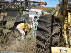
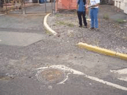
It is important to visit a site prior to finalization of a site investigation work plan. This is necessary to refine and finalize the designation of DUs and also helps ensure that the need to remove debris or clear vegetation prior to sample collection is identified and addressed prior to field activities. Multi Increment sampling methods require access to dozens or even hundreds of systematic random locations within a site for the collection of samples (refer to Subsection 4.2.4). Attempting to clear vegetation, or move debris, large equipment, vehicles, and other obstacles after the field team has already been mobilized to the site can significantly increase sample collection time and pose hazards for field workers (Figure 5-1).
|
The need to maneuver around debris and skip or alter increment collection locations can also compromise the representativeness of samples. Debris can also serve as a home for wasps, centipedes, fire ants and other stinging insects. Request the property owner to remove such material from the area well ahead of time. Check the site to make sure that this has been completed prior to mobilizing a field crew.
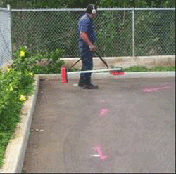
Thick grass and other vegetation can considerably slow down sample collection. Certain types of tall grasses can have thin sharp blades that require long-sleeve shirts for protection. Clearing of vegetation prior to sample collection can usually be done at a minimal cost in comparison to the overall investigation (Figure 5-2). Heavy equipment (e.g., bulldozer) can be used to clear DUs in heavily overgrown areas (Figure 5-3). Care must be taken not to significantly disturb or remove soil immediately beneath the surface vegetation root zone if the DQOs for the investigation target the area just below the surface root zone as part of the DU vertical layer. Where the site investigation DQOs includes sampling soil through the root zone, vegetation should be cut off just above the ground surface to allow access, rather than scraping the surface with a bulldozer.
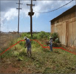 |
Figure 5-2. Clearing of Thick Grass |
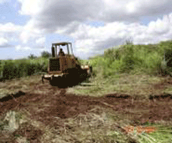 |
Figure 5-3. Bulldozer used to Cut Access Paths and |
Clearing prior to field work can also help identify otherwise unnoticed dump areas or suspect areas of elevated contamination within a designated DU that should be investigated as separate DUs. If clearing a site is not possible before site inspection or site investigation, then carry tools to do so in the field as necessary. This might include gas-powered weed trimmers, swing blades, saws, clippers or similar tools. A breaker bar (oʻo), essentially a long metal bar with a flattened and sharpened tip, can sometimes be used to punch holes through old asphalt for the collection of increments if a power tool is not available. Check with nearby hardware stores for daily tool and equipment rentals in order to minimize the amount of equipment that must be transported between islands. Note that vegetation can grow rapidly in many areas (especially the windward areas), with up to several feet of grass appearing in an area that was cleared only weeks before.
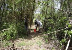
Characterization of DUs within very large heavily overgrown areas that cannot be cleared can be especially challenging. Strategically located paths corresponding to increment collection grid lines can be cut through large heavily overgrown DUs to provide access and stake out increment location points ahead of time (Figure 5-4). This can be time consuming but can also significantly improve the efficiency of field work and help ensure that representative samples are collected.
 |
|
Figure 5-4. Path Matching Increment Grid Locations |
5.2.2 SUBSURFACE UTILITY CLEARANCE
5.2.2.1 INFORMATION GATHERING
An effort must be made prior to subsurface field work to gather information on underground utilities or features at the investigation site. This primarily involves activities below a depth of three feet, but could also pertain to shallow utilities in the vicinity of buildings. Intrusive activities can involve drilling to collect soil cores, collection of soil gas samples and installation of monitoring wells as well as excavating and trenching. The goal of the information gathering and potential underground geophysical survey is to accomplish either or both of the following tasks:
- Locate subsurface utilities or features that may be targets of the investigation, (e.g., potentially leaking underground storage tanks) in order to aid in identifying the proper location, arrangement, and depths of subsurface samples to best investigate the identified object.
- Identify other subsurface utilities or features that should be avoided by the intrusive activity in order to minimize the potential for damage to underground utilities and other functional structures (e.g. utility lines) and to minimize potential for associated physical injury.
Pertinent information sources should be contacted prior to any field effort in order to obtain as-built plans, historical photos, utility maps and other available information concerning subsurface utilities and/or subsurface features at a site. Such information sources can include but should not be limited to the following:
- Utilities (e.g., Board of Water Supply, Hawaiian Electric);
- Communication companies (e.g., cable/telephone companies);
- Landowners or property management companies;
- Facility or site managers;
- Department of Defense or other federal agencies owning or controlling facilities;
- Utility Notification Center – One Call Center.
For the most part, the listed information sources will provide information only on a single type of utility (e.g., buried power lines owned by Hawaiian Electric) but will not provide the same information for other utilities or subsurface features at an individual facility. Additionally, the utilities might not provide information on lateral connections to their main service corridors. Conversely, landowners or facility managers might have information on multiple utilities or features but only for a single facility within the property or only for the immediate area around individual buildings at the facility.
|
One Call Center Background Hawaiʻi One Call Center, established in 2006, is similar to other centers operating throughout the nation requiring mandatory participation by both excavators (e.g., contractors) and operators (e.g., public utilities). The One Call Center system provides advanced warning to excavators of the location of underground lines before they begin digging. This mandatory “Call Before You Dig” program provides excavators with a single phone number to call for locating and marking underground lines, including lines for electric, gas, telecommunications, cable, water and sewer facilities. (www.DigSafelyHawaii.com) Hawaiʻi One Call Center Telephone Number |
5.2.2.2 ONE CALL CENTER NOTIFICATION
Use of the Hawai‘i One Call Center service is required by Hawai‘i state law, under Hawai‘i Revised Statute (HRS) Chapter 269E, enacted in 2006 (HRS, 269E). The law includes two requirements related to subsurface utilities in the State of Hawai‘i:
- That the State of Hawai‘i establish a one call center …”that provides advance warning to excavators in this State of the location of subsurface installations in the area of an excavation for the purpose of protecting those installations from damage.”
- That excavators within the state of Hawai‘i notify the one call center of the location of subsurface intrusive activity at a work site at least five working days before the activity.
The One Call Center in Hawai‘i (HOCC) is administered by the Hawai‘i Public Utilities Commission (PUC). Information on the HOCC, as well as answers to common questions, is contained in a handbook available from the PUC and One Call Center entitled “Dig Safely Hawai‘i” (PUC, 2008; www.DigSafelyHawaii.com).
The phone number for the Hawai‘i One Call Center is 1-866-423-7287. Information can also be submitted online (https://www.callbeforeyoudig.org/hawaii/index.asp) The service requires the following information by phone and in writing with respect to the site to be excavated or sampled:
- Site address;
- Maps and related information that identify the site location;
- The specific location(s) that subsurface work is to be conducted at the site, including marking proposed intrusive locations on the ground surface in the field with white paint;
- Contact information for the individual/agency responsible for or performing the subsurface work;
- The type of intrusive work being performed;
- The client or landowner for whom the work is being performed.
After receiving the information, the One Call Center will notify the publicly-owned utilities to mark the locations of their subsurface utilities or other features in and around the specific site work locations. The Utility Notification Center website states that: “…under normal circumstances it takes between 2 days to 5 days from the time you call (not counting weekends or holidays) to have the underground lines marked.” No fees are charged for this service.
Note that the HOCC does not cover federal facilities or other utilities or facilities not listed as “Participating Facility Operators” in the HOCC handbook (PUC, 2008).The HOCC is also not required to identify inactive subsurface utilities, even though these could interfere with subsurface activities.
5.2.2.3 FIELD EVALUATION OF POTENTIAL SUBSURFACE FEATURES
It is advisable to conduct an independent field effort to identify subsurface utilities or features in addition to contacting the HOCC. This should include a site inspection by a person knowledgeable of indications of subsurface utilities. Inspections with persons familiar with the facility since its inception can be invaluable. The site-specific SAP and Health and Safety Plan should define the clearance procedures that are necessary to identify the presence of subsurface utilities or other features that could impact or be impacted by sampling activity.
Facility construction diagrams can be a useful initial indicator of active or inactive subsurface utilities (e.g., a suspected former fuel pipeline). Field indications of potential subsurface utilities should be compared to information obtained earlier from HOCC and other sources. Manholes indicate access points to subsurface utilities. Long, linear patches in pavement often represent trenches dug for installation or subsequent repair of subsurface water, fiber optic or electric lines, or other types of pipeline (e.g., stormwater). Rectangular patches a few hundred square feet or smaller in area might indicate the location of an existing or former underground storage tank (UST). A U-shaped vent pipe extending from the ground surface and attached to the side of a building might indicate the presence of a current or former UST.
These features may or may not be present on construction drawings, particularly if the diagrams are out-of-date and site surface features used for orientation on the diagram such as buildings or fence lines have been subsequently removed or altered. If the linear patch in the above example corresponds to a fuel pipeline on the diagram and leads directly to a fuel valve pit then confidence in the construction diagram might be considered high. If the patch leads to a fire hydrant then the location of the fuel line, if indeed present, comes into question and further toning of the area may be required.
Locations of potential subsurface features should be marked on the ground surface by whatever means is appropriate for the surface cover at the sampling location. Multiple subsurface utilities or features can also connect or overlap at different depths, further complicating the investigation. The situation can sometimes create a complex subsurface environment as illustrated in Figure 5-5. Initial hand digging may be required at such locations if samples are to be collected. Hand digging, or other methods such as air or water jetting, may be required at some facilities. The latter can pose problems with the integrity of the samples collected and must be discussed in the investigation work plan.
|
The photograph depicts field indicators for subsurface utilities or underground features as follows:
- Potential subsurface feature running left to right indicated by the cut in asphalt in the upper left center portion of the photo. This surface indication does not continue in the right center portion.
- Manhole and potentially associated cut suggest a storm drain parallel to the previous feature. In this case the field indicator was found to relate to a subsurface feature. Subsequent comparison to as-built plans showed the cut was unrelated to the storm drain and instead indicated yet another subsurface feature.
- Surface cut in the yellow curb, an associated break in asphalt cover associated with the curb cut, and an apparently connected asphalt patch in the upper right corner of the photo suggest yet another potential subsurface feature.
5.2.2.4 SUBSURFACE SURVEY METHODS
A wide variety of commonly available surface-based survey methods can be used to identify and evaluate potential subsurface features at a site. Common survey methods used in Hawai‘i include the following:
- Resistivity/Electromagnetics;
- Magnetometer; and
- Ground-Penetrating Radar
Resistivity/Electromagnetics
Electromagnetics and resistivity (EM) are the general name for a variety of methods to measure for changes in subsurface electrical conductivity. The methods provide a means of measuring the electrical conductivity of subsurface soil, rock, and ground water. Electrical conductivity (the inverse of electrical resistivity) is a function of the type of soil, porosity, permeability, and the conductivity of fluids in the pore spaces. The EM method can be used to map natural subsurface conditions and conductive contaminant plumes. Additionally, trench boundaries, buried conductive wastes such as steel drums, metallic utility lines, and steel underground storage tanks, might be located using EM techniques (see Figure 5-6). Equipment and operators for EM methods are readily available in Hawai‘i. Under ideal circumstances the methods are able to penetrate several hundred feet of soil or bedrock for mapping of large-scale, subsurface changes (e.g., soil or rock interfaces). The methods are more commonly regarded as good to excellent for detecting single objects (e.g., pipelines or 55-gallon drums) at depths of 6 to 8 feet below ground surface (bgs) (Nielsen, 2006). The disadvantage to the methods is that they are potentially affected by metal fences, piping, buildings and vehicles at the surface.
 |
|
Figure 5-6. Subsurface Survey to Identify Underground Features Example of survey to identify features prior to intrusive sampling. The photograph depicts use of an EM detector to identify subsurface utilities. Painted arrows on the asphalt surface mark the location of a utility line. |
Magnetometer
Magnetometers measure the intensity of the earth’s magnetic field. The magnetometer will respond only to ferrous materials, including differences between subsurface soil and rock types (Nielsen, 2006). The presence of boulders, drums, underground tanks or pipes in the subsurface can cause measurable changes in the field. Magnetometers are readily available and typically have a depth penetration of 25 to 50 feet, depending on the type of instrument and the size, type, and number of objects in the subsurface. The presence of multiple drums in a burial pit will, for example, create a larger signal than a single drum.
Ground-Penetrating Radar
Ground-Penetrating Radar (GPR) uses electromagnetic waves from the high frequency radar spectrum (100 to 1,000 megahertz [MHz] range, radiated downward into the ground from a transmitter and reflected back to an associated receiving antenna, to identify subsurface changes in layering, cementation, moisture, and density, including the presence of voids and fractures (Nielsen, 2006). The receiver and antenna are usually towed in tandem over the area to be surveyed. Reflections of the radar wave occur whenever there is a change in dielectric properties of the subsurface materials.
GPR has both advantages and disadvantages over other subsurface survey methods. Under ideal conditions GPR can produce a much higher resolution of subsurface features (down to inches) in comparison to other geophysical methods. A continuous plot of subsurface data over time and location can produce a relatively rapid and picture-like image of subsurface features. “Echoes” from dense material can, however, obscure imaging of deeper features. High soil moisture, particularly in saltwater or brackish environments, can also mask subsurface features.
A GPR investigation performs best in coarse or massive material that is dry (e.g., unconsolidated coralline sediments, sandy soils and unweathered basalt formations). Subsurface penetration of 15 to 30 feet bgs can often be obtained, an effective depth for most environmental investigations. The high electrical conductivity of expansive clays or saprolite derived from volcanic rock can limit the usefulness of GPR in some areas of Hawai‘i. Clays can cause the GPR signal to rapidly attenuate and limit penetration to only a few feet. Consult an expert with experience in Hawai‘i prior to initiating full-scale use of this method. Experienced operators and GPR equipment can be expensive and difficult to obtain in Hawai‘i.
5.3 SURFACE SOIL SAMPLE COLLECTION
The collection of samples reflects the culmination of significant research and planning prior to initial field activities. It is important that the samples ultimately collected be as technically defensible and representative of site conditions as possible. As discussed in Subsection 4.2.5.2, the tool(s) selected for sample collection must ensure that soil increments are core-shaped or otherwise not biased with respect to depth and of relatively equal mass, and that mass of individual increments be adequate to collectively meet the target bulk mass for resulting Multi Increment samples.
The collection of Multi Increment samples from exposed surface soil should be relatively straight forward with proper planning and tools. The top two to six inches of soil bgs is generally considered for surface soil DUs, depending on the site-specific DQOs (USEPA, 2011d; CalEPA, 2013). On Hawai‘i sites, the top 0-6 inches or 0-4 inches of soil are commonly selected for surface soil DUs. The same tool used for surface soils can often be used to collect deeper, near-surface soil samples (e.g. 6-12 inches bgs) if that is part of the site investigation objectives, or required to further delineate contamination that is documented at the surface. The collection of Multi Increment samples from DUs layers greater than one to three feet bgs typically requires the use of drills or other equipment (see Subsection 5.5). Although not typically carried out for surface soils, methods for the collection of Multi Increment samples to be tested for VOCs are described in Subsection 5.6.
Various types of sampling equipment are available for the collection of surface soil samples. Soil type, compaction, abundance of rocks, and increment depth typically drive selection of the most appropriate tool for a given site. For example, a simple sampling tube is generally most appropriate for relatively non-compacted, fine grained soils. Sampling tubes with core catchers or using a trowel might be most appropriate for very loose, sandy soil, although care must be taken with the latter to collect increments that are not biased with depth. An electric drill with a bit specially designed to remove cuttings can allow the rapid collection of increments and Multi Increment samples in fine-grained, semi-compact volcanic soils common in the Hawaiian islands. A sample tube with a slide hammer, a mattock, electric hammer, or in some cases even a backhoe may be required to collect samples in very compact or very gravelly soil.
The discussion below is presented in terms of tool options for various soil types and field conditions. These are presented as general guidelines only and based in part on the field experience of HEER Office staff; some tools might be applicable for multiple soil types and site conditions. As previously discussed, an inspection of the site to assess soil conditions by someone experienced in sample collection is imperative. Multiple types of tools should be carried to the field to address unanticipated field conditions and ensure that representative samples can be collected.
Wire flags, marked tape measures or rope, and rolling measures can be used to fully or partially mark the location of individual increments to aid in Multi Increment sample collection, based on the targeted increment spacing, and DU documentation (see Subsection 4.2.4). Ensure that all sampling devices are of sufficient quality to avoid contamination of the samples being collected with paint, chrome plating, grease or other material. Sampling equipment should be either: (1) easy to decontaminate, or (2) cost-effective enough to be disposable.
5.3.1 SOFT, FINE-TO COURSE-GRAINED SOILS
|
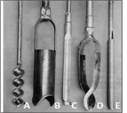
The most common hand tools used for the collection of surface soil samples are sampling tubes or coring devices (“C” and “E” in Figure 5-7) and screw-type drills (“A” in Figure 5-7). Stainless steel soil coring devices rather than augers are recommended for the collection of Multi Increment samples. Augers tools (“B” and “D” in Figure 5-7) can mix soils throughout the vertical depth penetrated, or penetrate a variable width column through the depth of interest, and therefore may be less reliable. If augers are used, methods used to avoid or address these types of problems should be clearly discussed in the site investigation report. Even using the screw –type drills (“A” in Figure 5-7) requires careful attention to extract the full length or core of soil from the targeted depth, as soil can be mixed through the vertical increment drilled. Coring devices made of other materials (e.g., plastic) might also be appropriate for certain contaminants or soil sampling situations.
Small-diameter (e.g., 0.75 to 1.5 inch) sampling tubes are generally preferable in soft or loose, clayey to sandy soils that are not rocky. The tubes are simple, efficient and effective and can help minimize compaction and disturbance of a site when increments from multiple near-surface layers are being collected. They are a good primary sampling tool for quick sampling events, for very large DUs where considerable walking is required, and for cases when only one person is collecting samples. They also serve as a useful backup or alternative to a drill (see below) because there is no need to wait for batteries to charge. Importantly, small-diameter tubes also allow for the collection of 30- to 50-gram increments from the upper 4 to 6 inches of soil, ideal for the collection of a Multi Increment sample.
Larger diameter tools (e.g. 2 inch and up) collect a proportionately larger amount of soil from a single location and may require extra subsampling of the final bulk MIS sample in the field or by the laboratory. Talk with the laboratory to know the maximum total mass of bulk MI sample they are willing to accept and process using their standard MIS processing protocols (typically in the range of 2.0 to 2.5 kg), and select a sample core diameter that will keep you at or under that total mass for the number of increments that will be collected. Note that larger mass bulk MI samples are generally more representative, so the choice of the sample core diameter is a balance between what is effective to utilize in the field, amount of contaminant heterogeneity expected, and cost for the laboratory to process.
Sampling tubes are utilized with extension rods and T-handle attachments (Figure 5-8).The tube is twisted into the ground to the desired depth, cutting into and retaining the soil in the hollow, open-face core barrel. The tube is then withdrawn to extract the increment from the ground. The increment is then removed and placed into a collection bucket for the DU sample. A flat-edged screwdriver or similar tool is useful for removing an increment of clayey or hard-packed soil.
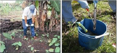
Figure 5-8. Collection of Increments with a Sampling Tube Left photo: Use of an open-sided sampling tube to collect surface increments in soft soils. |
A foot-assisted coring tool developed by the Army Corps of Engineers can also be useful for the collection of increments in soft but cohesive fine-grained soils (Figure 5-9; USACE, 2007). The core barrel is pushed into the soil and retracted. The increment is extruded into the container with a spring-operated plunger. These tools can allow the very rapid collection of Multi Increment samples in uncompacted soils without gravel.
|
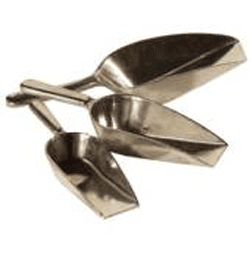
Sampling tubes and core barrels such as those shown above do not work well in very loose soils that lack sufficient cohesion and will not allow particles to be retained or removed by the tool. Use of core catchers, if available for the coring device in use, may be an effective alternative. Alternatively, scoops with flat bottoms or similar hand tools are generally utilized in these conditions (Figure 5-10). If scoops or trowels are utilized, it is important to remember that the goal is to remove similar-sized core-shaped increments in the DU (increments of uniform diameter through the vertical depth targeted), as well as limit increment mass to that needed to prepare a bulk, 1-2 kg Multi Increment sample. The flat lip of the scoops shown in the figure 5-10 can help to ensure that wedge-shaped increments are not collected (refer to Subsection 4.2.5.2).
|
5.3.2 MODERATELY COMPACT, FINE-TO COURSE-GRAINED SOILS
Figure 5-11. Use of Cordless Drill for Sample Collection Cordless drill used with one-inch diameter, hollow auger bit to collect surface soil samples. Wear nitrile or latex gloves and change gloves between DUs (not shown in demonstration photos). Upper left photo: Use of a 28V cordless rotary hammer drill to collect increments (e.g. Milwaukee or Grainger models) Use a paper plate with a pre-cut, one-inch hole placed on top of increment location. The center of the plate must be held down to keep soil from piling up under the plate; keep any tears around the hole pressed together to minimize soil loss. |
A cordless drill used in conjunction with a paper plate can be time and cost-effective for semi-compact to hard-packed soils without significant gravel, but can require two people unless a specially designed, foot plate is used (Figure 5-11). Use a heavy-duty cordless drill (such as a 28V) with a one-inch drill bit and a battery or portable generator. Weaker drills are prone to overheat or quickly drain batteries, especially in clayey or hard-packed soils. These drills can generally be used for up to 100 increments per battery and field chargers are available for vehicles. Drills powered by portable generators can often be rented from local tool rental or hardware stores.
Use a one-inch, hollow auger bit (e.g., Speedbore bit) to improve soil removal from the ground and control the collected soil mass (see Figure 5-11). These bits generally produce 30 to 50 grams of soil per six-inch depth.
Hollow center auger bits typically work better in the field than wide-flight bits (Figure 5-12). Hollow auger bits are designed to more efficiently remove cuttings from a boring without bringing up excess soil. The area where soil is removed from a boring is less easy to control with a wide-flight bit, and the bits can either bring up too much or too little soil with respect to the target increment mass.
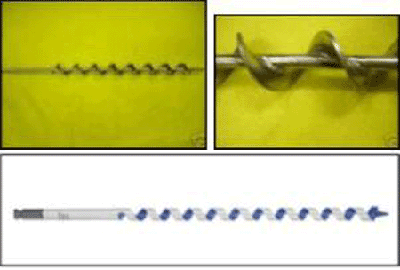
Figure 5-12. Comparison of Auger Bit Designs Upper photos: One-inch diameter wide-flight auger; can work in loose soil but depth and volume of soil recovered can be difficult to control. |
Heavy-duty paper plates work well in the field under dry conditions (see Figure 5-11). Pre-cut holes save field time; several plates might be required per DU if the plate tears excessively during increment collection. Wooden or metal plates might also be useful. Care should be taken not to get fragments of the plate into the sample due to potential interference in laboratory analysis from glues or metals targeted as part of the site investigation.
The drill bit does not need to be decontaminated between increments within a single DU but must be decontaminated between replicate samples and between DUs. Recent sampling kits available from soil testing supply stores include a metal foot plate with a drill guide that attaches to the base of a sampling bucket, with increments directly deposited into the bucket (see Figure 5-11).
Heavier duty drills with portable generators are also an option (Figure 5-13). This setup avoids the need for recharging batteries and is able to drill through more compact soils. These drills should only be used by an experienced person, however. The sudden torque of the drill if a rock or compact object is encountered can cause severe injury to the wrists.
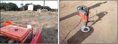
Figure 5-13. High-Powered Drill and Portable Generator Left photo: Using a high-powered, Hilti drill with a portable generator (photo from Weston Solutions) |
A manual, hydraulic, or electric slide hammer can also be used to advance the coring device into shallow soil (Figure 5-14). Slide hammers are effective for collecting harder packed soils but require considerable effort and energy to use in the field. A weighted slide hammer is physically lifted and lowered along a guide rod to drive the attached tool string into the ground to collect shallow soil samples.
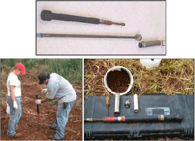
Figure 5-14. Use of a Slide Hammer to Collect Soil Increments Top photo: A slide hammer assembly with rod and split spoon coring tool |
5.3.3 VERY COMPACT AND/OR GRAVELLY SOILS
For very hard or gravelly soils, a hammer-action electric drill with a masonry bit or spade bit can be very useful to loosen the soil (Figure 5-15). A hand trowel is then used to collect an increment from the location. The trowel should be used in a manner to allow collection of a core- or slab-shaped increment that collects an equal amount of soil from the entire targeted depth.
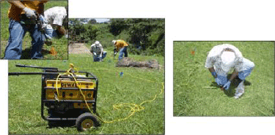
Figure 5-15. Use of an Electric Hammer and Spade Bit Left photos: Electric hammer (14 lb) connected to 4,000 watt, gasoline-powered portable generator used to loosen dense, hard-packed soil. |
Generators, drills and bits are usually available for rent from a local hardware store. Gradually push the soil to one side as the bit moves toward the targeted depth, opening up a small gap in the ground (Figure 5-16). Use a trowel to remove a core- or slab-shaped increment from side of opening, being careful to collect an equal amount of soil from all depths. Remove large rocks from the bulk Multi Increment sample as it is being collected. Ensure that an adequate amount of <2mm material is being collected per increment to prepare a bulk sample. Collect a similar mass of finer-grained soil from each increment location to the extent practical.
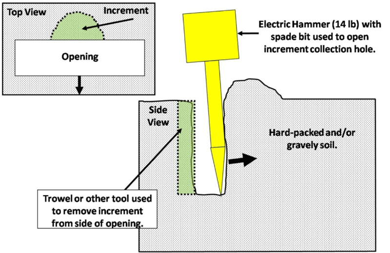
Figure 5-16. Collection of Increments Soil Loosened by a Spade Bit or Heavy Duty Hand Tool |
Other options include the use of a mattock or heavy-duty rock hammer to loosen core-shaped volume of soil from the hard-packed ground (Figure 5-17). A trowel is then used to collect the increment. This avoids the need to carry and rely on an electric drill and generator but adds significantly to the time and effort required to collect samples.
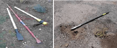
Figure 5-17. Heavy Duty Hand Tools Left Photo: Narrow spade (root digger), oʻo (pry bar) and mattock for collection of increments from hard-packed soil |
Heavier duty hand tools can also be useful to break through hard surfaces or cut through concrete or asphalt it order to access underlying soil. This can be very labor intensive, however, and can significantly slow down sample collection activities. Chisel or spade bits used with an electric hammer show above or a tunnel bit used with an electric drill (Figure 5-18) can be used to more rapidly remove plugs of asphalt or concrete.
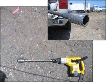
Figure 5-18. Tunnel Bit Use to Cut Through Asphalt or Concrete and Access Soil (Dewalt 2-3/4 inch x 22″ bit shown) |
Tunnel bits are not recommended for the collection of increments from hard-packed or gravelly soil, in spite of the ability to extract a core-shaped cutting. The mass of material collected inside a standard, 2 ¾ inch bit exceeds that needed for the collection of a 1-2 kg Multi Increment sample, requiring subsampling of the bulk Multi Increment sample in the field or laboratory to reduce mass for additional processing. Removing soil and large gravel from the bit can also be tedious and time consuming.
5.4 SUBSURFACE SOIL SAMPLE COLLECTION
Designation of Decision Units for the collection of subsurface Multi Increment samples is discussed in Subsection 3.4.”Subsurface” soil is generally considered soil that is below one foot bgs or soil that is otherwise difficult to access with standard tools used for surface samples. A subsurface DU can be thought of as a surface DU that is covered with an additional layer of soil. The fact that the targeted DU layer is covered by additional soil does not negate the need to collect high quality samples (refer to Subsection 4.2). The same applies to characterization of sediment that is covered by a layer of water.
Shallow subsurface soil (e.g., <12-18 inches bgs) might be accessible using a sampling tube, slide hammer, or electric drills as described in Subsection 5.3 for surface soils. Hand tools such as shovels could also be used to access deeper soil. The collection of increments and samples below this depth or from hard-packed soils will generally require the use of a push rig able to collect continuous cores. A backhoe or similar equipment can also be used for trenching or pot holing in order to gain access to deeper soil.
Overviews of push rigs and other drilling equipment are provided in ASTM Standard D 6169 (ASTM, 2005b) and ASTM Standard D 6286 (ASTM, 2006c). Direct push technologies can be used to collect samples to depths of up to 30 feet bgs or more, depending on the compaction of the soil and the presence of rocks. Auger drilling can reach depths of 100 feet bgs or more. Rotary drilling can reach depths of 1,000 feet bgs or more.
Each of these technologies is discussed in more detail below. Although included in the discussions below, auger and rotary drilling is more amenable to geotechnical investigations or the installation of monitoring wells than the collection of soil samples. This is due to the difficulty in collecting continuous cores as well as the expense, effort, and space required to operate the equipment. Drill cuttings and cores from such equipment might, however, be useful for initial screening of subsurface conditions and the need for a more intensive investigation (e.g., presence of absence of staining, potential COPCs, boundary between contaminated fill and native soil boundary, etc.; (see Subsection 3.4.4).
Tables 5-1 and 5-2 discuss the various drilling methods and performances.
5.4.1 DIRECT PUSH TECHNOLOGIES
Direct push technologies are a category of equipment that push or drive small-diameter hollow steel rods into the subsurface without rotating the drill rods. Direct push drilling can yield high-quality continuous cores of soil from targeted depth intervals quickly and cost effectively in the right type of soil conditions and is ideal for MI sampling strategies. Push rigs can also be used to collect soil gas or groundwater samples. Soil gas sampling is discussed in Section 7. The use of push rigs to install small-diameter monitoring wells for groundwater collection is discussed in Section 6.2. Smaller track-mounted rigs could be used for sampling areas with limited space. These rigs also normally remotely controlled and can be programmed to collect increments from a pre-established grid.
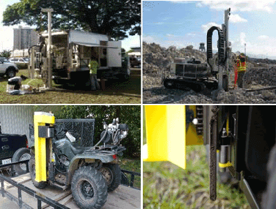
Figure 5-19. Direct Push Drill Rigs Upper Left Photo: Truck-mounted push rig; solid drive cap and rod just prior to breaking into the subsurface. The hydraulic hammer, just above the drilling rod, moves up and down by a hydraulic piston, which can use the rig’s weight to drive the drilling rods into the ground. Stabilizing legs are used for balance as needed. |
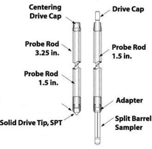
Figure 5-20. Drilling Rods for a Direct Push Drill Rig Rod on left used to achieve specific sampling depth; solid drive cap penetrates into subsurface. Rod on right is the split barrel sampler. Multiple samplers may be used to delineate the entire soil column. |
A hydraulic hammer is used to progressively drive the steel rods into the soil, with the weight of the drill rig used to provide a constant force on the drill string (Figures 5-19 and 5-20). Casing is advanced with a solid point held in place by an internal rod. A 1.5 to 2.25-inch diameter inner rod and core barrel are typically combined with a 3.25- to 4.5-inch diameter outer casing. As each section of the rod is advanced into the subsurface, another section of casing and rod can be attached to achieve greater depths. Two- to five-foot drive rods and samplers are typically used, depending on the depth and thickness of the targeted DU layers. Multiple drives might be required to extract the full length of core needed.
The steel rods and driving tip are pulled from the subsurface when the top of the desired soil interval (i.e., top of DU layer) is reached, with the outer casing left in place. The solid point is removed from the end of the inner rod and a split-spoon or open-barrel sampler is attached.
A split-spoon sampler is a stainless steel, machined, hollow cylinder that can be opened lengthwise into two halves (Figure 5-21). Split spoons can be used with hand-operated slide hammers, push rigs or larger drilling rigs. The cylinder is fitted with threaded ends. A cutting shoe is connected to the downhole end and a driving cap is connected to the uphole end. Split-spoon samplers can be lined with a clear Teflon or polyethylene lining to help keep cores intact after the sampler is opened. Six-inch stainless steel or brass tubes are also sometimes used, although they are less amenable for the collection of Multi Increment samples.
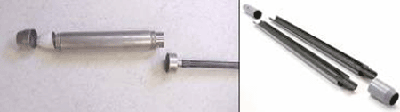
Figure 5-21. Split Spoon Sampler Left Photo: Assembly shown with cutting shoe to left and end cap to the right and threaded to extension rod. |
After the coring device is attached, the drill string is placed back into the casing and driven to the desired depth. A hydraulic hammer can be used in conjunction with the push rig for compact soils. The drive rod can be marked to help monitor depth (e.g., every six inches). A drop hammer can be used to measure blow counts as part of a Standard Penetration Test if required as part of the investigation (ASTM, 2011b). For example, a 140 lb hammer is dropped 30 inches and blows counted to advance each of three consecutive, 6-inch increments for a total of 18 inches. The resulting data are used to help evaluate structural properties of the soil, including consistency, in-situ strength, and susceptibility to liquefaction.
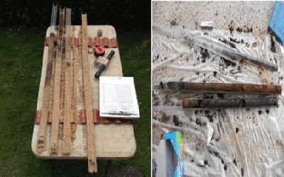
Figure 5-22. Continuous Cores Collected using a Push Rig Left Photo: Push rig cores with top of acetate liner removed to access soil |
The drill string is retracted and brought back the surface after the base of the targeted interval has been reached. A continuous and relatively undisturbed core is ideally collected within the device. The sample barrel is opened and the core exposed (Figure 5-22). The top of the plastic liner, if used, is cut away to allow access to the soil.
5.4.2 BOREHOLE CORE INCREMENT SUBSAMPLE
Each core section represents a single increment for a targeted DU layer in the same manner that a smaller core of soil collected from a surface DU with a sampling tube represents a single increment for that DU. Initial single borings might be collected to help target subsurface DU layers for more detailed testing and identify contaminants of potential concern (see Figure 5-22). If so, then the entire, suspect interval of the core should be submitted to the laboratory for processing as a single sample. The collecting of discrete soil samples from specific depths within a core rather than targeting specific depth intervals for MI sampling is not recommended (see Subsection 4.2.8.2 and Section 4.3).
Targeted DU layers are identified and marked in the core (Figure 5-23). The mass of an individual core increment collected with a push rig is typically too large for use in preparation of a bulk Multi Increment sample, and field subsampling of the core increments is required. Each increment for an individual DU layer is subsampled, with the extracted soil placed in a container specific to that layer. This can be accomplished by cutting a narrow wedge of soil from the entire length of the increment interval or by removing regularly spaced plugs of consistent mass from the increment (e.g., 5-10 grams; see Figure 5-24).
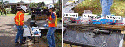
Figure 5-23. Identifying Targeted DU Layers in Cores Left Photo: DU core increment placed on table for inspection and subsampling. |
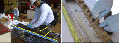
Figure 5-24. Subsampling of Core Increments for Preparation of a Bulk Multi Increment Sample Left photo: Removal of a continuous wedge of fine-grained soil from a core increment |
Under ideal circumstances the wedge method is preferred, since the resulting subsample provides 100% vertical coverage of the core increment. Removal of a continuous wedge from a core may not be possible if rocks are present or loss of volatiles may be an issue, however, and subsampling of core increments using the plug approach is most common.
Increment subsamples are combined in the field to prepare a single, bulk Multi Increment sample for the DU layer in the same manner as carried out for surface soil bulk Multi Increment sample. Note the individual soil plugs are subsamples of a single core increment and do not represent individual increments themselves. Individual subsample plugs cannot be counted towards the total number of increments collected from a subsurface DU layer since they were not collected from independent, random locations. The minimum recommended number of increments for testing of a DU (e.g., 30 to 75; see Subsection 4.2.2) does not apply to subsampling of core increments using subsample plugs.
The mass of soil included in a single core wedge or as the sum of plugs removed from a single core increment is dependent on target mass of soil designated for the final bulk DU layer. For example, if a 1.5 kg bulk sample is desired and 30 core increments are to be collected to represent a DU layer, then the mass for each core increment subsample should total approximately 30-50 grams. Careful consideration of the soil subsample mass collected from each core increment prior to subsampling is critical in order to ensure that mass of the resulting bulk sample will be adequate to meet target requirements (e.g., 1-2 kg) but not so large that additional subsampling in the field or laboratory will be required.
If a core wedge cannot be collected, then the target subsample mass should be collected from what is anticipated to be a representative number of points within the core increment layer. For example, if the collection of an approximately 1 kg bulk Multi Increment sample from a one-foot thick DU layer is targeted, and thirty increment cores are to be collected in the DU, then six, five-gram plugs at a spacing of two inches could be extracted from each of the 30 one-foot thick core increments for a total bulk MI sample mass of approximately 900 grams for the DU layer. The mass of soil removed from each individual core increment should be kept constant, assuming a constant DU layer thickness. Maintain consistent wedge width or plug spacing for subsampling of core increments collected from DU layers with varying thicknesses between borings (see HDOH, 2011i).
The collection of replicate Multi Increment samples to evaluate the precision of both increment subsampling and the overall sampling approach is recommended (see Subsection 4.2.8.2). Replicate sets of increment subsamples (e.g., triplicates) should be collected from one or more of the targeted DU layers and combined into independent bulk Multi Increment samples for testing. If the resulting data are reasonably consistent (e.g., RSD <35%) then the precision of the subsampling methods used can be considered to be good (see Subsection 4.2.7). Independent sets of borings are used to collect replicate samples in select DUs in order to test the precision of the overall approach, in the same manner as done for surface samples.
5.4.3 PIT OR TRENCH SAMPLE COLLECTION
The use of pits or trenches to collect Multi Increment samples might be required in situations where considerable debris, rubble, or rock create obstructions in the subsurface. Pits and trenches can also provide useful information on the nature of subsurface soils within a DU.
Pits have also been used to collect increments from multiple DU layers at sites where heavy equipment is already readily available, or a push rig would have to be brought over from another island (Figure 5-25 and 5-26). Increments are collected from pit sidewalls in the same manner as done for a continuous core (i.e. in a core-like shape). It is again important to ensure that an appropriate mass of soil is included in each increment in order to meet the targeted bulk sample mass.
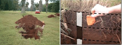
Figure 5-25. Use of Shallow Pits to Collect Increments from Multiple Layers within a DU Left Photo: Backhoe used to dig increment collection pits with large DUs at a former golf course |
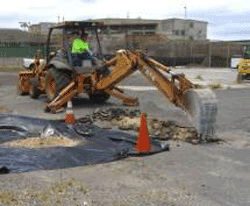
Figure 5-26. Example Use of Trenches for Site Investigation Increments collected from trench sidewalls at successive depths through DU layers in order to prepare bulk Multi Increment samples, being careful not to include collapsed sidewall material from upper DU layers. |
Trenches can be strategically placed within a DU to investigate the presence of buried debris and evaluate the soil stratigraphy as well as collect Multi Increment samples. When collecting increments at multiple or at successive depths in excavations, care needs to be taken not to collect material collapsed from the sidewalls of upper soil layers.
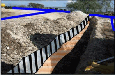
Figure 5-27. Use of Shallow Trenches to Collect Multi Increment Samples from Exposed DU Layers DU boundaries noted in blue. Surface Multi Increment sample (e.g., 0-6″) collected prior to excavation of trenches. Increments for subsurface DU layers collected across the full vertical thickness of the exposed targeted horizon in order to prepare a bulk Multi Increment sample (layers depicted). |
In Figure 5-27, a trench approximately three feet wide is excavated to a depth of three feet in order to access the sides of targeted DU layers for sample collection. An initial Multi Increment sample was collected from the surface DU layer (0 to 6 inches) using standard, soil sample collection methods. The trench was then excavated to the target depth. A Multi Increment sample was subsequently collected from exposed face of each of two targeted DU layers, situated from 6-18 inches and 18-36 inches below the ground surface. Increments were collected across the entire, vertical extent of the DU layer. With the possible exception of very narrow DUs, multiple trenches like that depicted in Figure 5-27 are typically needed to collect all increments in a systematic random fashion across DUs.
Field replicates can be collected within the same trench in order to assess the precision of the data with respect to the exposed portion of the DU layer. Independent sets of trenches within select DUs could be used to collect replicate samples in the same manner as done for surface samples and further assess the precision of the data.
Safety precautions are imperative to protect workers collecting samples during trenching. Note that the Hawai‘i Occupational Safety and Health Division (HIOSH) requires that any excavation that is over 4 feet in depth be shored or properly sloped when personnel will be working within the excavation (USDL, 2002). Use of the backhoe bucket to collect increments from sidewalls might be required for deep or otherwise unstable excavations.
5.4.4 HOLLOW STEM AUGER DRILLING
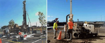
Figure 5-28. Hollow-Stem Auger Drill Rig Left Photo: Large rig for deep boreholes; requires a high overhead clearance for the mast. The auger flights (right in photo, on ground) are rotated and pressure is applied from the drill rig to advance the drill string downwards. |
Hollow-stem augers were already in use for drilling and coring in unconsolidated soils for geotechnical work at the advent of environmental investigations in the 1980s. The use of auger rigs to collect soil samples has largely been replaced by more compact and efficient push rigs described above, although they are still frequently used for the installation of larger-diameter monitoring wells.
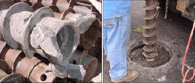
Figure 5-29. Auger Drill Bit and Drill String Left Photo: Bit attached to bottom of auger to move soil to the side as the rotating auger advances. |
Auger drilling usually requires a larger drill rig than is used with direct push drilling. The entire rig can stand 20 to 40 feet and require high overhead clearance (Figure 5-28). The use of auger rigs is described in ASTM Standard D 5784 (ASTM, 2006; see also USACE, 1996; Nielsen, 2006). The rigs are capable of reaching depths of 100 feet in unconsolidated to semi-consolidated soil and even coral, but cannot normally penetrate volcanic basalt or tuff formations.
Augers used for environmental investigations typically have an outside diameter of 6 to 10 inches (Figure 5-29). As the name implies, the auger itself is hollow with a helix wound around the outside. In this manner the auger serves both as a cutting tool to advance downwards and as casing for the collection of soil samples or the installation of wells. The tip of the bottom most auger string is designed to push soil cuttings to the outside of the flights where the helix can bring the cuttings to the surface.
As pressure is applied from the weight of the rig, the flights are rotated and the soil cuttings are brought to the surface by the flights. As the flight is drilled into the subsurface new flights can be added to achieve greater depths. Each flight must be removed individually to remove the auger drill string from the boring.
Similar to a push rig, the auger flights can be left in place while a split spoon or an open barrel sampler is used to collect a soil sample or a monitoring well is installed. The sampler is attached to the end of a heavy rod and driven to the targeted depth using a percussion hammer or hydraulic hammer. The coring device is then retracted and the sample removed.
Hollow stem auger can also be used to install monitoring wells (refer to Subsection 6.2). The monitoring well casing is installed within the auger once the desired depth interval is reached. Clean sand is placed around the monitoring well casing as the auger flights are slowly retracted.
5.4.5 ROTARY DRILLING
A detailed discussion of air or mud rotary drilling is beyond the scope of this technical guidance. Rotary drilling is generally used for geotechnical studies or the installation of wells through bedrock rather than for collection of soil samples (Nielsen, 2006; US Navy, 2007). These rigs are less amenable for the collection of subsurface soil samples to be tested for contaminants. Aside from the expense and space required to operate the rigs, complete recovery of cores during drilling is difficult when drilling in unconsolidated and semi-consolidated lithologies, such as clays, silts, and sands. The rigs are most useful for the collection of continuous rock cores for geologic or geotechnical studies. Standard rock coring methods are summarized in ASTM guide D 2113 (ASTM, 2008). Standard rotary drilling methods are summarized in ASTM guide D 5782 (ASTM, 2006b).
Rigs are typically designed for the use of multiple drilling methods, including both auger and air or mud rotary (Figure 5-30). In the simplest type of rotary drilling a drill rod with an attached bit is continuously rotated against the bottom of a borehole in order to pulverize and break up encountered material. The pulverized fragments are carried up to the surface by air or specially formulated mud pumped into the borehole and pushed back to the surface under pressure. The mud also serves to lubricate and cool the bit during drilling. Rotary drills can also be designed to collect continuous cores of material.
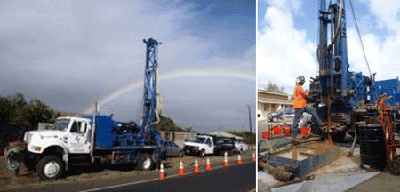
Figure 5-30. Large Truck-Mounted Drilling Rig Left Photo: Truck-mounted rig capable of both auger and rotary drilling. |
Drilling fluids, including air, are selected based on the anticipated nature of subsurface conditions, including soil or rock type, depth, temperature, and pressure. The HEER Office does not typically allow the use of any fluid other than air for drilling carried out as part of an environmental investigation. Drilling mud can compromise the representativeness of samples collected as well as introduce contaminants into the targeted formations. Use of a foam suppressant composed of a surfactant and polymer mud might be required, however, in rare cases where there is a need to core into a zone where potentially flammable product is present.
Figure 5-31 shows a compressed air drilling setup. Caution should be taken with air rotary rigs to prevent particles (or exhaust) from entering the borehole during drilling, particularly if samples are to be collected for contaminant analysis. On occasion, potable or distilled water may need to be added, but only in the situation that cuttings cannot be brought to the surface by air alone. Drilling under these circumstances should be discussed with the HEER Office before implementation.
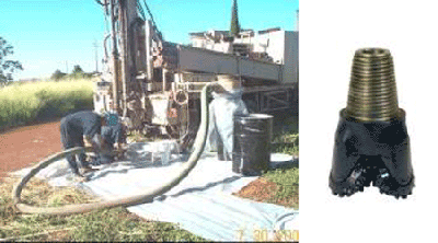
Figure 5-31. Pressurized Air Discharge from an Air Rotary Assembly Left Photo: Compressed air is pumped down through the drill bit and drives cuttings up through the outside of the core barrel. Cuttings and compressed air are directed to a cyclone mechanism (on right) that dissipates air pressure and velocity and allows for cutting collection in a drum below cyclone. |
Rotary core barrels typically range from 1 to 10 inches in diameter. A single tube core barrel is rarely used due to poor sample recovery and sample disturbance. A double tube core barrel is most frequently used in rock core sampling for geotechnical engineering applications. A triple tube core barrel is used in zones of highly variable hardness and consistency. In this design a separate, non-rotating liner is added to the double tube core barrel in order to improve sample recovery and minimize sample handling and disturbance (refer to US Navy, 2007).
A variety of coring bits, core retainers, and liners are used in various combinations to maximize the recovery and penetration rate of the selected core barrel. Example cores and coring bits are illustrated in Figure 5-32. Bits are fitted with diamond or carbide teeth to facilitate cutting. The outer barrel rotates to allow the bit to penetrate the formation. As the outer barrel is advanced, the sample rises and is retained in an inner liner, which in most drill string assemblies does not rotate with the outer barrel. The bit cuts an annular groove in the formation to allow passage of the drilling mud or air. Cuttings are forced up the outside of the core barrel. A split-spoon barrel is typically used to collect five-foot cores.
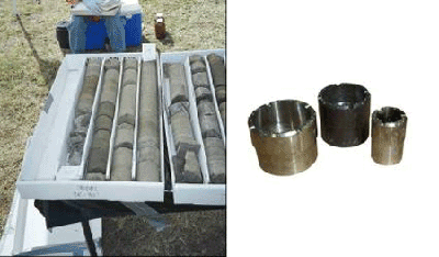
Figure 5-32. Example Recovered Cores and Rotary Drill Coring Bits Left Photo: Rock Cores Collected Using Air Rotary Drilling. |
| Table 5-1. Overall Performance Estimation for Various Types of Drilling/Excavation Methods | ||||
| Direct Push | Hollow-Stem Auger | Rotary Drilling | Trenching | |
| Relative Site Impact | Low- Moderate | Moderate | High | Low-Moderate |
| Relative Cost | Low- Moderate | Moderate | High | Low-Moderate |
| IDW Generated | None to Minimal | Moderate to High Volume | High Volume | Moderate to High Volume |
| Depth Potential | Shallow (to approximately 30 feet) | Moderate (to approximately 100 feet) | Deep (to 1,000 feet) | Shallow (to approximately 20 feet) |
| Soil Condition Limitations* | Un consolidated | Semi-Consolidated Unconsolidated | Consolidated | Semi-Consolidated Unconsolidated |
| Monitoring Well Installation Size | Small (1 inch well casing) | Medium (2 to 6 inch well casing) | Large (2 to 24 inch well casing) | None |
| Types of Sampling | Soil Gas, Soil, and Groundwater | Soil and Groundwater | Soil and Groundwater | Soil and Groundwater |
| Vehicle Requirements | Truck mounted | Specific Heavy Rig required | Specific Heavy Rig required | Excavator or pick/shovel |
| Other Issues | Vehicle access | Vehicle access, overhead clearance | Vehicle access, overhead clearance | Open area required, access for excavator |
| Notes:* Also See Table 5-2: Relative Performance of Commonly Utilized Drilling/Excavation Methods Versus Commonly Encountered Substrate |
||||
| Table 5-2. Relative Performance of Commonly Utilized Drilling/Excavation Methods Versus Commonly Encountered Substrate | ||||
| Subsurface Formation/ Material | Direct Push | Auger-Hollow Stem | Trenching | Air Rotary |
| Sand | E | G | G | NR |
| Loose sand and gravel | E | G | G | NR |
| Loose boulders in alluvium | NR | P | G | NR |
| Clay, silt | G | E | E | NR |
| Coralline Limestone with and without fractures | NR | NR | NR | E |
| Tuff | NR | P to G | NR | E |
| Basalts-thick layers | NR | NR | NR | G |
| Basalts-highly fractured | NR | NR | NR | P |
|
||||
5.5 COLLECTION OF SAMPLES FROM STOCKPILES
The designation of DUs for stockpiles is discussed in Subsection 3.4.6. Sampling strategies and methods specific to stockpiles are discussed in the HEER Office document Guidance for the Evaluation of Imported and Exported Fill Material (See Appendix 3-A; HDOH, 2017d). A summary is provided below.
It is important to allow equal access to all soil with a stockpile DU for the collection of increments. Increments collected from only the exposed surface of a stockpile, for example, might not be representative of deeper soil. When space is available, the stockpile should be flattened to a thickness of three feet or less to allow equal access to all soil in the pile. Increments are then collected from the top, middle, and bottom of the pile in a systematic random fashion (Figure 5-33).
Figure 5-33. Collection of Increments and Multi Increment Samples from a Flattened Stockpile Increments are collected alternately from top, middle, and bottom of flattened DU in order to collect a representative bulk Multi Increment sample. |
Another option is to collect increments as the stockpile is being formed (Figure 5-34). For example, increments could be collected from front-end loader buckets at appropriate intervals of soil volumes as the soil is being excavated or moved. Increments could also be collected as piles are formed at the end of a conveyor belt, or when stockpiles are being moved from one location to another. This allows equal access to each portion of the pile as it is constructed, avoids the need to reconstruct a stockpile, and saves space required to flatten a stockpile for sampling. The collection of soil samples during these activities can interfere with the operation of heavy equipment, however, and requires close coordination with the other parties.
Figure 5-34. Examples of Opportunities to Collect Increments and Bulk Multi Increment Samples during Stockpile Formation or Movement |
A third option is to progressively characterize small volumes of soil in an unflattened stockpile as needed (Figure 5-35). Increments could be collected from the surface and shallow depths within the exposed face of the stockpile. Soil represented by the resulting, bulk Multi Increment sample can be cleared for reuse or disposed as appropriate. Replicates could be collected as described, but from alternate systematic random locations from the surface and shallow depths within the exposed face of the stockpile to assess the precision of the sample collection method.
Figure 5-35. Progressive Testing of DUs from an Unflattened Stockpile Increments collected from the surface and shallow depths within the exposed face to prepare the bulk Multi Increment sample. |
5.6 COLLECTION OF MULTI INCREMENT SAMPLES FOR VOC ANALYSIS
Testing of Multi Increment samples for volatile organic compounds (VOCs) is discussed in Subsection 4.2.8. Samples to be tested for VOCs are typically collected from cores that represent increments extracted from subsurface DU layers rather than exposed surface soils (see Subsection 3.4.4). Testing of samples from freshly exposed faces of excavations for VOCs might be required as part of a response to a recent spill or for remedial actions, however (see Subsection 3.4.5).
The collection of soil samples to be tested for VOCs is similar to that described for non-volatile contaminants, except that increments (or more likely subsamples of DU layer increments collected from cores) are placed in an extraction solution in the field. The collection of samples to be tested under this method should be discussed with the laboratory well in advance of field work. A sampling and analysis work plan should also be provided to HDOH for review prior to the commencement of field activities. The analytical laboratory should be consulted prior to sample collection to discuss sample containers, sample handling, preservative type and volume, shipping of samples in methanol, anticipated laboratory method detection limits, etc.
Method 5035 allows for samples to be extracted in the field by placement in a selection of solutions, based on desired detection limits, sample preservation method, and holding time limitations (USEPA, 2002h; refer also to MADEP, 2002, TRNCC, 2002 and CalEPA, 2004b). The guidance recommends that soil samples, or in the case of Multi Increment sampling methods soil increments, to be tested for VOCs should be placed in containers with pre-measured amounts of either methanol (most common) or reagent-grade (e.g., distilled) water. However, the use of reagent-grade water for preservation is not recommended by the HEER Office due to concerns regarding extraction efficiency and very short hold times (See Subsection 11.2). The volume of the solution (typically provided by the laboratory in pre-weighed amber bottles) is based on the anticipated mass of soil sample to be collected. Although individual increments are not typically weighed in the field, coring devices with calibrated sample collection volumes are generally utilized so reasonable estimates of total mass can be made. The total mass of soil placed in the solution should closely match what was planned for a particular DU/site investigation to help ensure the amount of methanol provided by the laboratory is adequate to keep the soil covered by methanol at all times.
Methanol is the most commonly used solution for field preservation of soil samples. This allows for a holding time of 14 days prior to analysis by the laboratory. The samples should ideally reach the laboratory within 48 hours in order to verify that methanol is not being lost from the sample container. Potential problems with the use of methanol include an increase in method detection levels due to the need to dilute the solution for analysis, as well as logistical issues related to obtaining, storing and shipping the flammable solution around the islands.
The use of water as an extraction solution is not recommended (See Subsection 11.2. This approach was included in the original, USEPA 5035 lab method in order to allow for lower detection limits of VOCs in soil in comparison to samples extracted into methanol (USEPA, 2002h). Improvements in laboratory methods since that time should provide methanol based reporting limits of 50 µg/kg for volatile chemicals, which is more than adequate for screening purposes. The water-based extraction is also significantly less effective in comparison to methanol according to laboratories contacted by the HEER Office. While the precision of the data in terms of the analytical method might be higher than for methanol, there is a strong possibility that the concentration of the VOC reported will under-represent the actual concentration in the sample collected. In addition, VOCs will be less tightly held in water than in methanol and can be lost when the sample bottle is opened repeatedly to add increments. A further disadvantage is that samples must either be tested within 48 hours or frozen to -7ºC by that time and then tested within seven days from the sample collection date. This limited holding time can pose additional problems for samples that must be shipped to the mainland for analysis.
The use of an acidic, sodium bisulfate solution as an alternative to water provides both an extended holding time (up to 14 days) and allows for similarly low detection levels. Reaction with organic matter, effervescence and loss of VOCs in calcareous soils, and other potential problems interfere with the use of this approach in the field, however. Both of these issues can be significant problems in Hawai‘i and the use of sodium bisulfate is generally limited (See Subsection 11.2; and Alternative Approaches, Subsection 5.6.3).
5.6.1 INCREMENT COLLECTION
A volume of methanol adequate to accommodate the estimated mass of increments to be collected for a Multi Increment sample is placed in the sample bottle prior to collection of the sample (Figure 5-36). A minimum 1:1 ratio of solution to soil is recommended (i.e., 1 milliliter of methanol to 1 gram of soil). The laboratory will typically provide sample jars with pre-measured amounts of the solution based on direction from the sampler regarding the approximate mass of soil to be added. Additional methanol may be required to ensure the sample mass is completely submerged. This should be discussed with the laboratory that will receive and analyze the samples.
To select the appropriately sized sample container, consideration should be given to the total volume of soil to be collected and preservative required. A minimum 300 g mass of soil should be collected to prepare a bulk Multi Increment sample (refer to Subsection 4.2.3). For example, 60 increments of 5 g each for a total of 300 g of soil (minimal mass recommended for Multi Increment samples) would require approximately 300 ml of preservative. Utilize a container that is large enough to accommodate additional preservative (if needed) and to prevent loss of preservative through splashing as soil increments are dropped into the container. This can normally be accomplished using one-liter, amber glass bottles pre-filled at the laboratory with 300 ml of methanol.
It is very important to remember that soil samples (increments) collected for VOC analysis need to be placed in methanol as soon as possible (i.e. within a minute or two) to prevent potential loss of volatiles due to volatilization and/or biodegradation. Good planning of the field sampling effort is essential to help ensure VOC samples are collected appropriately.
Figure 5-36. Subsampling DU Layer Increments from Borehole Cores with Methanol Preservation Upper Left Photo: DU layers identified in core (depicted by arrows). Upper Right Photo: Core increment subsampled by collection of 5 gram plugs at regular spacing to collect targeted increment subsample mass (inexpensive TerraCore™ sampler shown). Subsample plugs placed in jar with pre-measured volume of methanol intended to provide a 1:1 ratio of methanol to soil. |
5.6.2 SUBSURFACE DU LAYERS
Small coring devices, as described in Subsection 5.4.2, can be used to collect Multi Increment samples from subsurface boring cores to be tested for VOCs (HDOH, 2011i). Recall that each section of core extracted from a targeted DU layer represents an increment, as is the case for surface Multi Increment samples (see Subsection 4.2.7). Individual core increments extracted from borings will normally need to be subsampled prior to placement in a container due to their large mass (see Subsection 5.4.2).
Evenly spaced plugs of soil should be removed from the core increment and placed in the preservative solution (i.e. methanol) container specifically designated for that DU layer (Figure 5-36). The use of plugs rather than wedges helps to control the total mass of soil collected, and may result in less disruption of the soil core that could contribute to loss of volatiles. Subsamples from core increments from other borings installed into the same DU layer are progressively added to the container as the field investigation advances in order to prepare a final bulk Multi Increment sample for that layer.
The mass of soil removed (subsampled) from each individual core increment should be kept constant, assuming a constant DU layer thickness, and adequate to ensure that a minimum 300 g bulk Multi Increment sample is collected from the DU layer. As a default, the collection of 5-10 g plugs every 5-10 cm (2-4 inches) along a core increment is recommended (refer to HDOH, 2011i). This should be adjusted based on target mass of soil to be collected from a targeted DU layer. Maintain consistent plug spacing for subsampling of core increments collected from DU layers with varying thicknesses between borings (see HDOH, 2011i).
As noted in Subsection 5.6.1, when sampling VOCs in soils it is important to ensure that soil is placed in the preservation fluid (methanol) within a few minutes after collection to reduce losses due to volatilization and biodegradation. This can be especially challenging when collecting samples or subsamples from multiple subsurface borings and multiple DU layers per boring. Very close coordination is necessary between the drill crew and the sampling crew to coordinate appropriate timing and handling of each soil boring to minimize the time between soil extraction and subsampling into methanol. The timing of each soil boring collected by the drill crew should be carefully synchronized with the rate at which the sampling team can access and subsample the soil boring quickly. A well organized work station for processing the subsamples needs to be set up, all sample containers should be pre-labeled to save processing time, and adequate storage containers/coolers provided to accommodate samples collected. If a nearby indoor workstation is not available for use, then a field work station with tarps or covers for rain, sun, and/or wind protection will likely be needed. An adequate number of personnel are needed on the sampling team to ensure subsamples from all DU layers in the soil boring can be obtained and placed in methanol within minutes of each boring being obtained and opened for access.
Increments should be collected using tools that minimize the loss of volatile chemicals during sample collection (i.e. cause the least disaggregation of soil during collection) and allow the collection of at least a five-gram mass of soil. Syringe-type, core-shaped devices that can be pushed directly into the soil are preferable. Examples include the TerrCore™, Core N’ One™ and Encore™ tools (see Figure 5-36). Plastic, inexpensive devices that cannot be sealed (e.g., disposable syringes with forward ends cut off, TerraCore™ device) are most suitable for sample collection when methanol can be used in the field. These types of devices can also be used for the collection of samples to be tested for nonvolatile chemicals.
Somewhat more costly but sealable, Core N’ One™ or Encore™-type devices are commonly used to collect increments or increment subsamples for projects where the use of methanol in the field is not practical (see Subsection 5.6.3 below).
As depicted in Figure 5-36, the device is pushed into the soil, retracted, and the increment collected is immediately extruded into a container with a premeasured volume of preservative (e.g. methanol). Then end of device can be trimmed to make a scoop for subsampling of gravelly soils. This is repeated with each increment or increment subsample. Dedicated sampling devices should be used between different DU layers within a single borehole, but can be reused for subsampling of core increments in multiple DU boreholes for the same DU layer.
A single large jar with a pre-measured volume of methanol adequate for the entire targeted DU layer could in theory be used to prepare a bulk Multi Increment sample in the field (i.e., plugs from subsample increments combined from 30+ borings). However, this risks an expensive total loss of the sample should the jar be accidentally broken in the field or at the laboratory.
An alternative approach is to place subsample plugs for individual core increments into a smaller jar specific to each borehole (e.g., see HDOH, 2011i). Methanol from individual jars (aliquots) representing the same targeted DU layer can then be combined at the laboratory for testing. This approach can also allow for different vertical and lateral combinations of core increments to be evaluated in order to obtain a better resolution of the location of the core mass of contamination at depth, and help optimize remediation (see HDOH, 2011i).
Subsample replicates should be collected from 10% of the borings and compared to evaluate the precision of method used (refer to Subsection 4.2.8.2). This will involve the collection and combination of three separate sets of subsample plugs from the same boring for each of the targeted DU layers. The relative standard deviation of the replicate data sets should be compared and subsampling methods modified, as needed, to achieve acceptable precision. Increasing precision could require a decrease in plug spacing and/or an increase in the mass of subsamples collected from individual increments.
5.6.3 ALTERNATIVE APPROACHES
Because methanol is a hazardous material with flammability and toxicity concerns, shipping by air is highly restricted unless it is in accordance with specific rules. The U.S Department of Transportation and the Airline industry (International Air Transportation Association or IATA) regulations on air shipping of hazardous materials provide “Excepted” quantities of methanol that can be shipped by air without special packing materials or special training/certification of the shipper. The excepted quantity for air shipping of methanol is no more than 30 milliliters per inner container, and a maximum of 0.5 liter per cooler or package. There is no limitation on the number of separate coolers or packages that can be shipped as long as each one meets the “Excepted” quantity requirements (confer with airline used and applicable IATA regulations). Those that are shipping Excepted quantities still need to ensure that the package(s) are properly labeled, and they have knowledge regarding the samples and sampling methods used. Check with the shipper beforehand to ensure that containers are properly labeled and shipping requirements met. Restrictions could vary between islands and airlines. For shipping methanol above the Excepted quantities, a hazmat-trained shipper or packer should be utilized, or someone with equivalent training/certification and knowledge of applicable IATA regulations.
Wherever volumes of methanol greater than 30 milliliters per container presents problems for air shipping (especially for sites not on Oʻahu) alternatives can be considered in consultation with the laboratory. For example, collect Multi Increment increments into the full recommended volume of methanol in the field. Agitate the sample and allow the solution to equilibrate over a twenty-four hour contact period. Decant at least 20ml of the solution into a standard 40ml VOA vile (check with laboratory on required volume). This alternative should only be conducted under a specific SOP provided by the laboratory and is included in the site investigation report. Ship the samples to the laboratory under the “Excepted” quantity category for methanol (in accordance with airline used, and applicable IATA regulations). Method 5035A also notes that sonification of samples at 40°C for 30 minutes can be carried out for samples with less than 24 hours contact, so if this option is available it could be used shorten methanol contact time required before subsampling and shipping samples by air (include this practice in SOP with laboratory, if used). Note that the remaining spent methanol mixture is classifiable as a listed hazardous waste and must be managed accordingly (F003, spent, non-halogenated solvents; Hawai‘i Administrative Rules §11-262-11). The spent mixture might also be classifiable as a hazardous waste due to ignitability. However, quantities of waste methanol generated will likely be minimal, in which case regulations for conditionally exempt small quantity generators found in Hawai‘i Administrative Rules §11-26—1-5 will apply (100 kg limit).
A potential limitation of the extraction of samples in methanol is an increase in method detection limits (MDLs). This could cause the MDLs to be above relevant HDOH EALs for certain targeted chemicals. Multi Increment soil samples for volatile analyses can be tested using Selected Ion Monitoring (SIM) laboratory methods to reduce method reporting limits to target action levels for samples preserved in methanol. The SIM methods target a small number of select compounds instead of a full standard VOC list, and typically allow an order-of-magnitude reduction in reporting limits in comparison to standard Method 8260 analysis.
Another alternative used in Hawai‘i due to methanol air shipping restrictions is to immediately freeze individual MI increments for shipping and have the increments combined in methanol at the laboratory prior to analysis (refer to USEPA, 2002h; also see Subsection 11.2). Individual increments for MI samples are collected in separate sampling devices that have vapor tight seals and are designed for zero headspace (e.g. Core N’ One™, EnCore™, or equivalent type sampler). The samples are either stored on ice between 2°C and 6°C and must be analyzed within 48 hours, or immediately frozen in the field to between -7°C and -15°C (or stored immediately on ice between 2°C and 6°C and frozen within 48 hours to between -7°C and -15°C) and must be analyzed within 14 days of sample collection (see Subsection 11.2). Note that to freeze samples in small cores with vapor-tight seals to temperatures between -7°C and -15°C (for temporary storage and shipping) use water ice with added salt (Hewitt, 1999), and document that suitable freezing temperatures are achieved. Dry ice may be another option, though sample temperatures could go below -20°C and compromise the integrity of the seals on the small air-tight cores. Consequently, if dry ice is utilized packing methods should be developed to keep the dry ice from direct contact with the samples and document that temperatures of the samples remain between -7°C and -15°C. Check with the shipper for procedures to ship dry ice, including the amount of dry ice that can be placed in a single cooler, package labeling, and requirements for the use of a vented cooler.
Although not ideal, the approach of freezing individual increments of MI samples for VOC analyses may be unavoidable for samples collected on islands other than O´ahu due to the logistical difficulties of obtaining, storing, and shipping methanol from other islands and the time required to ship samples to a laboratory on the mainland for testing. If problems persist, then the DQOs of the investigation should be reviewed and discussed with the HEER Office. High-quality (e.g., MIS) data with elevated detection limits are preferable to low-quality data (e.g., discrete soil samples) with lower detection limits. In most cases use of the laboratory detection limit as a screening level when the EALs cannot be met will be acceptable (refer to EHE guidance; HDOH, 2016). If discrete soil samples are collected and tested then the data should be considered usable for qualitative, screening level purposes only (e.g., presence or absence). Decision making should be supported by the collection of soil gas sample data at the site (recommended for all sites impacted with potentially significant amounts of VOCs; refer to Section 7).
5.7 SEDIMENT SAMPLING
5.7.1 SEDIMENT SAMPLING EQUIPMENT
A brief overview of sediment sampling approaches and equipment is provided below, primarily for shallow sediment sampling scenarios. This section will be expanded in the future to include more detailed information. Well-thought-out Decision Units and investigation objectives are required for sediment investigations in the manner as done for soil investigations. Multi Increment samples should be used to characterize sediment DUs (see Section 4). Random, small-scale variability limits the reliability of data for small discrete sediment samples. This can be especially critical for vertical characterization of contaminants in sediment.
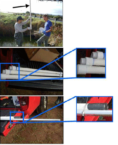
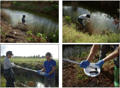
Additional procedural information on sediment sampling is available from many sources including Superfund Program, Representative Sampling Guidance, Volume 5: Water and Sediment (USEPA, 1995c), USGS National Field Manual for the Collection of Water-Quality Data (USGS, 2005), and Field Sampling Procedures Manual (NJDEP, 2005). These documents focus on older discrete sample collection methods but still include useful considerations for Multi Increment sampling approaches.
With proper planning and equipment, the collection of Multi Increment samples from sediment in relatively shallow water (e.g., <15 ft deep) does not involve significantly more effort than required for the collection of surface soil samples. Various types of sampling equipment are available for collecting sediment samples. Consider the type and characteristics of the water body associated with the sediment to be sampled when selecting sampling equipment. Factors such as the width, depth (especially if tidally influenced), flow, and bed characteristics of the water body are important.
Increments collected from sediment should be core-shaped (see Subsection 4.2.5.2). Consider a tube-shaped sampler for collection of increments to ensure cylindrical-shaped increments (see Figures 5-37 and 5-38).
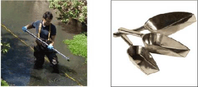
If the sediment cover is exceptionally thin (e.g., < 4 inches) then use of use of a cup-type device or a flat-bottom, scoop sampler might be most practical (Figure 5-39). These devices might also be required for the collection of increments from coarser-grained sediment or other situations where use of a core catcher for the tube sampler is not practical. A flat-bottom scoop with upright square sides (Figure 5-39) will also help to avoid bias to the upper portion of the sediment.
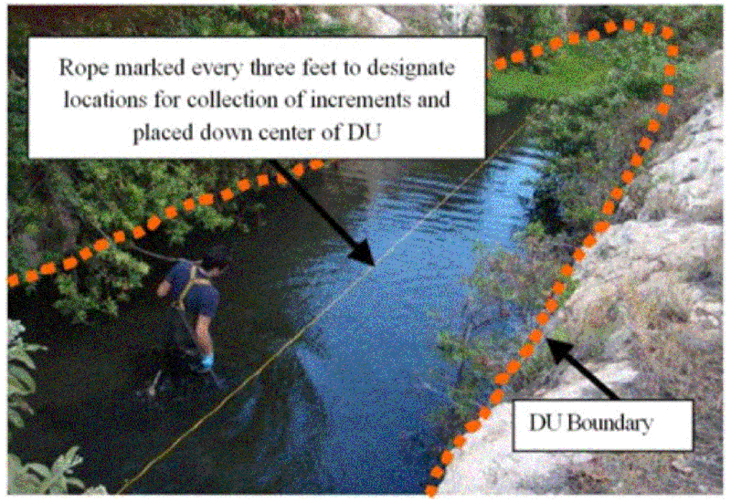
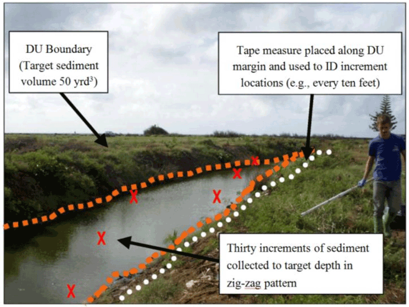
Marking sediment increment collection locations in a stream or canal can be challenging. Consider placing a long, floatable rope (or tape measure) with a marked spacing within the DU (Figure 5-40). A long tape measure with increment positions marked by pins or flags can also be placed along the edge of the waterway to guide sample collection (Figure 5-41). Refer to Subsection 4.2.5.1 for guidance on increment spacing in long, narrow DUs.
Take care to minimize disturbance and loss of an increment as the sampling device is being lifted. If sediment fines are preferentially lost during increment collection then the resulting Multi Increment sample will not be representative. Decant excess water from collected sediment Multi Increment sample by waiting several minutes and then carefully pouring excess water out of the container. Use a cellulose paper filter to catch and re-place fine sediment back into the container as necessary. Note that the collection of undisturbed, anaerobic sediment samples for geochemical analysis, if required, might require alternative methods. This should be discussed with the HEER Office prior to sample collection.
Alternative tools and methods are required for the collection of sediment samples from larger and/or deeper water bodies. Figure 5-42 depicts a core sampler used to collect Multi Increment sediment samples from the large estuary pond depicted in Figure 3-32 of Section 3. Twenty-four Multi Increment samples consisting of 30 increments each were collected from 6 DUs designated in the pond over a 4-day period, including triplicates from one of the DUs.
A clear two-foot tube is attached to the end of the extendable push rod. A small boat and GPS can be used to maneuver to pre-established, increment collection locations within the pond. The coring device was manually forced into the sediment to the targeted depth and retrieved. A valve at the top of the sampling tube helps to hold in the sediment as the core is extracted from the increment location. As the core is being from the water, the base of the sampling tube is capped to prevent sediment loss. The sampling tube is then removed from the valve/push rod, capped on the other end and stored.
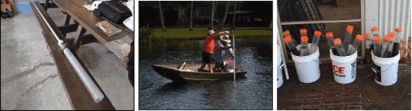
Once all cores (e.g. 30) for a DU have been collected, the individual cores containing multiple DU layers are extracted from the sampling tubes and the respective DU layers are combined to form bulk MI samples(Figure 5-43). The base cap is removed from the bottom of the tube and the tube placed on a plunger. The upper cap is removed and the tube is progressively forced downwards. Targeted DU layers are removed and placed in containers specific to that DU layer to form a bulk Multi Increment sample.
Bulk Multi Increment samples can either be sent to the lab for processing or, if needed, processed in the field to reduce mass. In the latter case, the sample is placed on clean, plastic sheeting and spread out to a thickness of about ½ inch (Figure 5-44). A flat edge spatula is then used to collect subsamples from the sample in a systematic, random fashion. A minimum of 30 subsamples is recommended. The initial bulk sample and/or split samples can be submitted to the laboratory for further processing and testing in accordance with incremental sampling methods.
|
|
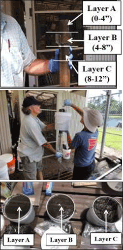
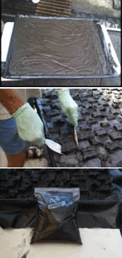
Alternative types of sediment samples are available for deeper or otherwise less accessible sediment. A Vibracore sampling tool was used to evaluate the feasibility of collecting Multi Increment samples from deep-water (50 ft) in a field study carried out by HDOH in 2013 (Figure 5-45). A small pontoon boat equipped with a GPS was again used to locate pre-established increment location points. A 30-increment Multi Increment sample from the upper foot of sediment in a DU was collected over a period of five hours using the approach described below.
A metal sampling tube with an inner liner is fitted to the base of an electric motor. The device is lowered to the sediment interface using a small wench. The motor is then used to vibrate the sampling tube into the sediment. The depth of penetration is monitored at the surface using a tape measure attached to the top of the device. A sediment catch is connected to the base of the tube to retain the sediment core when collected. To help speed the collection effort, an 8 foot long collection tube was used to collect up to 6 to 8 one-foot deep increments (target layer depth was 0-1 ft below sediment surface in the DU) without bringing the vibracore aboard the boat between collecting those increments. After the first increment was collected (and held in the tube by the sediment catch) the vibracore was lifted off the sediment floor several feet and slowly moved to the next increment location for another 1-foot sediment collection in the same sampling tube.
The sampling device is then retrieved to the surface. The liner and sediment core are removed from the sampling tube. An attempt to collect subsample increments to reduce the mass of the larger volume of sediment collected in the 8 ft core by cutting wedges or regularly spaced plugs had limited success (Figure 5-46; see also Subsection 5.4.2).The repeated vibration action of the vibracore during the period that multiple DU increments were collected in the same sampling tube (as well as the nature of the sediment in that location) tended to cause the sediment in the tube to disaggegate and run or mix together. If sediment collected under these circumstances is to be representatively subsampled, the sediment from the entire core would need to be collected, spread to a thin layer on a large flat surface, and systematic random increments collected, as illustrated in the example in Figure 5-44.
An additional concern noted in the use of the Vibracore was the loss of some very fine sediment when the sample tube was placed horizontally on the pontoon boat for core liner extraction. If the sediment in the core liner can be removed from the core tube in a vertical orientation (or other technique to limit loss of fine sediment particles), that would result in a more representative sample for contaminant evaluation.
Other devices used to collect surface sediment samples include center pivot grabs, clamshell pivot grabs and drags, sleds, and scoops. Sediment core-type samplers are capable of collecting sediment samples at depths comparable to benthic grab samplers and when feasible are more suitable for MI samples. Sediment core samplers have the ability to retain the integrity of sediment horizons with minimal disturbance and allow the collection of unbiased core-shaped increments.
|
Several types of sediment core samplers and benthic grab samplers are described in the following documents, among other sources.
- New Jersey Department of Environmental Protection (NJDEP) Field Sampling Procedures Manual. August 2005.
- United States Geological Survey (USGS), National Field Manual for the Collection of Water-Quality Data, Book 9, Handbooks for Water-Resources Investigations, Chapter A8, Bottom-Material Samples. Version 1.1. June 2005.
For sediments that consist primarily of <2mm particles, consider subsampling Multi Increment samples in the laboratory for extraction and analysis without drying, in order to reduce sample preparation and analysis time. Drying and sieving are carried out primarily to remove large particles. A sediment moisture content analysis is also necessary if the laboratory subsamples are collected without first drying the bulk MI sample(s), in order to report the laboratory data on a dry weight basis.
If both sediment and surface water samples are collected in the same location, collect the surface water sample first. If several sediment samples are collected from a streambed, collect the most downstream sample first with subsequent samples collected while proceeding upstream. Follow appropriate sample handling and analysis procedures, which are described in Section 11.
5.8 FIELD DOCUMENTATION
5.8.1 SURFACE SOIL SAMPLING LOGS
Accurate field logs are essential for evaluation and interpretation of analytical results and for preparation of the site investigation report. Details of all field activities, both during initial site inspections and during sample collection, should be recorded. The latter includes documentation of the possession and handling of samples from the time of collection through analysis and final disposition. Copies of the sampling logs, pertinent notes, and photograph logs should be included in the site investigation report.
Similar information should be recorded for borings, trenches, or pits installed to collect MI samples from subsurface DUs as well as the use of any discrete soil samples for initial screening purposes. Deviations from the sample plan caused by conditions encountered in the field (e.g. inadequate tools for sample collection, unanticipated surface debris or subsurface obstacles in sample collection, weather delays, etc.) are also important to document. Site visits to assess field conditions prior to mobilization for the collection of samples are essential and should also be documented in field logs.
An example of a surface soil sampling log is presented as Figure 5-47. Include similar information for any discrete soil samples collected. The intended use of the discrete samples and limitations regarding their representativeness should be clearly discussed in the investigation report (refer to Subsection 4.3). Copies of the field logbook, sampling logs, and (if available) photograph logs should be included in the site investigation report.
A log should be prepared for each DU included in the investigation. The logs should at a minimum include the following information:
|
Figure 5-47. Example Surface Soil Sample Log |
Adequate information should be included in the sketch map and sample information log to generate a to-scale map of DU locations in the final report (e.g., shape, dimensions, adjoining DUs, landmarks, north arrow, etc.). Depictions of DUs on high-altitude (e.g., satellite) maps or with low-altitude (e.g., drones) photos is acceptable and even preferred provided that distortion is not too great to prevent accurate estimation of dimensions (Figure 5-48). Draft DU maps can be made prior to sample collection and adjusted in the field as needed. Final DU maps depicted on aerial imagery can significantly aid in future re-identification of investigated areas.
Figure 5-48. Demarcation of Decision Units and DU Information Using a Google Earth Image |
Coordinates determined via hand-held Geographic Positioning System (GPS) equipment is acceptable to record the boundaries of Decision Units (e.g. four corners of a rectangular-shaped Decision Unit). The accuracy of the equipment to be used should be documented in the SAP. Any potential variability caused by surrounding forests, structures, or other obstructions to the GPS unit acquiring satellite signals should be taken into account and documented in the investigation report.
A more detailed survey of the site and DU boundaries by a surveyor licensed in the State of Hawai‘i is required for maps to be included in an Environmental Hazard Management Plans (EHMP). This is necessary to more precisely document locations where contamination will be left in place for long-term management. The EHMP should include the latitude and longitude of key DU boundary points, along with ground surface elevation data determined within the Hawai‘i State Plane Coordinate System to an accuracy of 0.1 foot. Locations of existing buildings or other major landmarks should also be surveyed for reference to the targeted area under long-term management.
The basic rational for designation of the DU (e.g., suspect spill area, perimeter DU, etc.; see Subsection 3.4) should be noted in the site documentation. The tools and method used to collect Multi Increment (or other) samples should be described in the sample logs. Note the increment spacing used for each DU (see Subsection 4.2.4). Record any field processing of the sample(s) collected, including the need to reduce the sample mass due to the original bulk sample(s) being too large for lab processing (refer to Subsection 4.2.3).
Record information for field observations and field screening methods used to assist in the identification of potential contaminants of concern or test samples in the field (see Section 8). This might include visual and olfactory observations, or the use of tools such as a photo-ionization detector (PID), portable X-ray fluorescence device (XRF), immunoassay test kits or a field Gas Chromatography-Mass Spectrometry [GC/MS] unit. A dehumidification tip should be used with the PID. Field measurements should be recorded and included in the log for the targeted DU.
Recording the spacing of increments is important in order to document that the sample was collected in a systematic random manner. As discussed in Subsection 4.2.4, the specific locations of individual increments do not need to be recorded or included on a map of the DU. This is in part because individual increments cannot be assumed to be representative of the immediately surrounding soil, due to uncertainties from random small-scale variability (refer to Subsection 4.1.2 and Section 4.2.4). The exact location of any given individual increment collection point therefore does not need to be documented.
A basic soil description and classification should be included with the sample log (see Subsection 5.8.3). Additional and more detailed information regarding soil taxonomy, geotechnical properties and other characteristics that might be required to meet the project objectives should be included as appropriate. A brief overview of consistency, cementation, structure, rock classification, and other information is provided in Subsection 5.8.4.
5.8.2 SUBSURFACE SOIL SAMPLING/BORING LOGS
Logs for samples collected from subsurface DUs should include the same type of information noted above for surface soil samples regarding site conditions, sample collection methods, boring spacing, etc. Record the rational for the selection of targeted DU layers in the same manner as done for surface soil (refer to Subsection 3.5.6). This might include the anticipated known or anticipated depth of contamination, visual or olfactory evidence of contamination during test borings or abrupt changes in soil characteristics. Field processing of samples is typically required for subsurface Multi Increment samples due to the mass of individual core increments and should be described in the logs (refer to Subsection 5.4.2).
Additional information is required for exploratory borings or borings to be used for the installation of wells. A log for each boring should be prepared which includes the following items, as applicable:
|
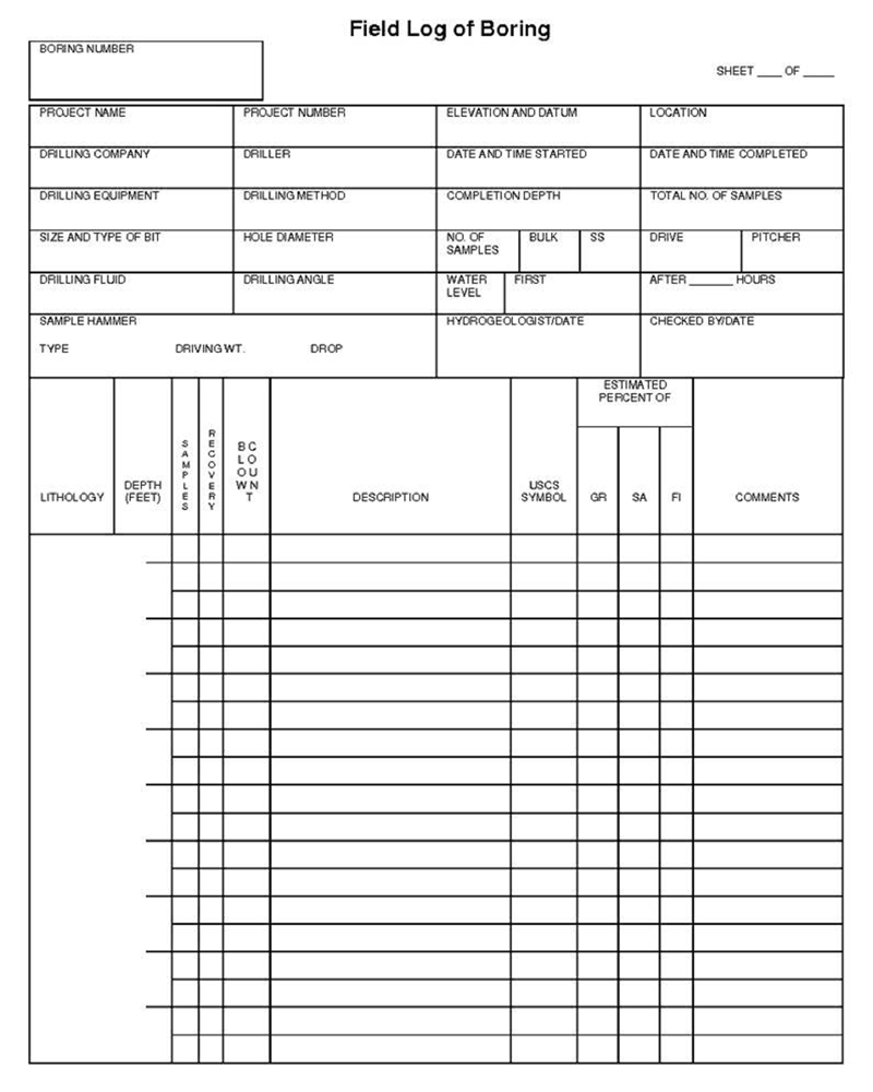
Figure 5-49. Example Log for Exploratory Borings or Borings Used for the Installation of Wells |
An example boring log is depicted in Figure 5-49. The soil descriptions should also include information on density or consistency (primarily when borings are conducted using hollow stem auger) and appearance descriptors of cementation, structural appearance of layers and other features, and other appearance descriptors as applicable to the project.
5.8.3 SOIL DESCRIPTION
Soil descriptions for soil sampling events should be made by a trained geologist, geotechnical engineer or soil scientist. The Unified Soil Classification System (USCS) is recommended for basic soil descriptions (ASTM, 2006d; see also ASTM, 2006e; USDA, 1987, USDA-NRCS, 2007; Nielsen, 2006; US Navy, 2007).
The level of detail appropriate for soil descriptions for a given site is tied to and should be addressed in the site investigation objectives (DQOs). At a minimum the color and estimated nature of the soil in terms of average particle sizes (e.g., gravel versus sand versus clay) should be recorded using a standardized approach. More detailed soil descriptions, including laboratory-based measurement of particle size distribution, might be required for more detailed investigations of contaminant fate and transport or to design remedial actions. Maps with taxonomic names for soil on each island are published by the US Department of Agriculture (USDA, 2015). The accuracy of the maps in highly developed, urban area where soil from other areas may have been imported should be verified.
A summary of key elements of the classification system is provided below. If an alternative classification scheme is used then a summary of terms used and particle size categories should be included in the report.
5.8.3.1 RECOMMENDED PARAMETERS FOR SOIL DESCRIPTIONS
Classification of soil in accordance with the USCS involves a group symbol, name, and complete word description (ASTM, 2006d). Key descriptive parameters include:
- Relative proportion of gravel, sand and fines and USCS classification name and symbol;
- Color (Munsell method preferred);
- Consistency;
- Moisture content;
- Staining/discoloration/odor;
- Glass, wire, porcelain fragments or other debris indicative of disposal or fill;
- Other descriptive terms
Descriptive terms denoting the geologic nature of the soil can also be added, including such terms as “saprolite” for soil directly derived from weathered rock or “sediment” for soil associated with unconsolidated terrestrial or marine sediments. Additional soil descriptors can be included as needed based on the DQOs of the investigation (e.g., plasticity, angularity, etc.; refer to ASTM, 2006d). Properties regarding the in situ structural nature of the soil might be required in projects that include a geotechnical component (e.g., density, structure, etc.). A review of properties commonly recorded as part of subsurface borings is provided in Subsection 5.4.
Include notes regarding odors and other observations during drilling, even if these are not apparent in the samples collected. Field aids that combine the USCS classification system with examples of particle sizes, percent estimation of individual components, color, particle angularity and other descriptive criteria are available commercially.
Classification Group Name
An abbreviated summary of the USCS classification scheme is provided in Figure 5-50 (after ASTM, 2006d). Soils are initially classified as “coarse-grained” or “fine-grained,” depending on the dominance of gravel and/or sand-size particles versus silt and/or clay-size particles. The term describing the dominant particle size is further modified based on the abundance of other particle sizes, with a code applied to each grouping. The classification scheme somewhat confusingly uses a minimum of 12% clay + silt to describe a sand or gravel as “with fines” but a minimum of 15% sand + gravel to describe a fine-grained soil as “with sand” or “with gravel.”
| Figure 5-50. USCS Soil Classification Scheme (after ASTM, 2006d) | ||||
| Major Divisions | Code | Description | ||
| Coarse-Grained Soils More than 50% retained on a 0.075 mm (No. 200) sieve | Gravels 50% or more of course fraction retained through a 4.75 mm (No. 4) sieve | Clean Gravels (<5% fines) | GW | Well-graded gravels, sandy gravels or gravels with sand; little to no fines |
| GP | Poorly-graded gravels, sandy gravels or gravels with sand; little to no fines | |||
| Gravels with Fines (>5% fines) | GM | Sandy gravels with silt, gravels with sand and silt | ||
| GC | Sandy gravels with clay, gravels with sand and clay | |||
| Sands 50% or more of course fraction passes through a 4.75 mm (No. 4) sieve | Clean Sands (<5% fines) | SW | Well-graded sands, gravelly sands, or sands with gravel; little to no fines | |
| SP | Poorly-graded sands, gravelly sands, or sands with gravel; little to no fines | |||
| Sands with Fines (>5% fines) | SM | Silty sands, sands with silt | ||
| SC | Clayey sands, sands with clay | |||
| Fine-Grained Soils More than 50% passes through a 0.075 mm (No. 200) sieve | Silts and Clays | ML | Silt, sandy silt, clayey silt, silt with fine sand and clay | |
| CL | Clay, silty clay, clay with silt and fine sand | |||
| OL | Organic silt and clay (loam) | |||
| Highly Organic Soils | PT | Peat and other highly organic soils | ||
Notes:
|
||||
If the second-most dominant grain size makes up >30% of the soil type then include that grain size with the name. For example a soil composed of 30% fines and 75% sand is described as a “silty-clayey sand (SM).” If dominance of the fines by silt versus clay is known then a more specific code can be assigned, for example “SM” for a silty sand or “SC” for a clayey sand. Note that it can be difficult in the field to distinguish between fine sand, silt and clay without significant experience.
A sand with 12% to <30% silt and clay is described as “sand with fines (SM-SC).” Sands with 5% to 12 % fines require dual symbols that include a description of grading, for example “well-graded sand with silt (SW-SM)”. A sand with <5% fines is simply described in terms of grading, for example “poorly graded sand (SP)”.
Fine-grained soils with >30% sand or gravel are described as “sandy” or “gravely.” Fine-grained soils containing 15% to <30% sand or gravel are described by adding “with sand” or “with gravel” to the group name (e.g., silt and clay with sand, ML-CL). Although not called for in the ASTM document referenced above, it is reasonable for the purposes of an environmental investigation to add “with sand” or “with gravel” to fine-grained soils that contain 5% to 15% coarse-grained particles. Dual classification of a soil type is appropriate if a sample has properties that do not distinctly place it into one group (e.g., SC/CL). Refer to the documents referenced above for additional soil descriptive terms.
Visual Estimation of Grain-Size Distribution
In practice the accurate classification of soils with a large fraction of fines can be challenging in the field without first drying and sieving the sample. Detailed analysis of particle size distribution is most accurately carried out in the laboratory if required as part of the investigation DQOs (e.g., Method D422; ASTM, 1998). As an alternative, field estimation of particle size distribution can be carried out in the following manner:
- Select a representative sample (Multi Increment sample preferred).
- Remove all gravel-size (>75mm or approximately three inches) or larger particles from the sample. Estimate and record the percent by volume of these particles. Only the fraction of the sample smaller than 75mm is classified.
- Estimate and record the percentage of gravel.
- Considering the rest of the sample, estimate and record the percentage of sand particles, typically the smallest particle visible to the unaided eye.
- Assign the remaining percentage to “fines”; do not attempt to separate silts from clays.
Estimate percentages to the nearest 5 percent. If one of the components is present in a quantity considered less than 5 percent, indicate its presence by the term “trace.” Percentage composition figures can assist in estimation of different size or particle type makeup of a sample. More precise lab methods might be required to accurately distinguish fine sand from silt and accurately determine clay composition if this information is required for completion of the field investigation.
Munsell Color
Color is described by hue and chroma using the Munsell Soil Color Chart (Munsell, 2000). For uniformity, the HEER Office recommends that investigators utilize this chart for soil color classification. This assists in comparisons of soils from different areas of a site or between sites. The Munsell Color Chart is a small booklet of numbered color chips with names like “5YR 3/4”, a specific type of reddish brown. The first part of the code (e.g., 5YR) describes the sample in terms of the basic color group (“hue”). The second part of the code (e.g., 3/4) describes the color in terms of lightness and darkness (“value”) and color intensity (“chroma”).
Descriptors should also note layering, mottling, gradation, or banding of colors. It is important to note and describe staining that might be related to contamination, particularly if the observation is correlated with other observations of odor, moisture, or appearance (e.g., presence of apparent petroleum liquids or green staining possibly related to contamination with copper-chromium-arsenic).
Consistency
Consistency describes the strength at which soil particles are held together. Descriptors include:
- Loose – Soil easily falls apart;
- Friable – Soil initially holds together but easily crushed with gentle pressure;
- Firm – Soil crushes under moderate pressure and resistance is noticeable;
- Very Firm – Strong pressure required to crush soil; difficult to accomplish with thumb and forefinger.
Soils that are loose and easily crumbled even when wet are usually indicative of a low clay content. Dry soil that is very firm is usually indicative of a moderate amount of clay.
Moisture Content
The moisture content of the soil should be described qualitatively using the following terms and the corresponding definitions:
- Dry – Absence of moisture, dry to the touch.
- Moist – No visible water but moisture is sufficient to bind soil matrix.
- Wet – Visible water, usually when soil is sampled from a water table. In other instances, the wetness may also indicate the presence of non-aqueous phase liquid (NAPL), if accompanied by strong odor or unusual liquid color or viscosity.
Submit samples to a laboratory for followup moisture analysis.
Staining, Odor and the Presence of Contamination
Unusual odors should be noted in logs and soil descriptions if detected when sampling, as they may be related to hydrocarbons, solvents, or other chemical contamination in the subsurface. Hydrocarbon odor may range from gasoline to lubrication oil. Contaminant-related odors also might have a distinctive smell of decaying vegetation or a stronger astringent or sweet odor that could be indicative of solvent compounds.
Use of a field organic vapor analyzer for screening purposes is recommended when volatile or semi-volatile organic contaminants are expected at a site (refer to Section 8). Direct inhalation should be avoided if odors suspected to be related to contaminants are detected. A health and safety plan should be prepared for sites where volatile or semi-volatile contaminants are anticipated. A respirator may be required under some circumstances, in additional to other personal protective equipment (e.g., gloves, tyvex suits, safety boots, etc.).
Note and describe staining or unusual moisture found in combination with unusual odors, as the combination of characteristics is often indicative of solvents, petroleum or other Non-Aqueous Phase Liquid (NAPL) contamination in soil (i.e., separate phase liquid not dissolved into water). The staining or moisture indicative of NAPL is often gray to brown in hue but can range in appearance from clear to completely black. Gasoline sometimes imparts a greenish to bluish hue to soil. Along with unusual odor and color, the moisture indicating NAPL contamination most often has an unusual textural aspect. For example, hydraulic fluids may feature a tacky or sticky feel accompanied by a sweet odor, while lubrication oil is most commonly much more viscous than water and accompanied by a dark color and a heavy, musky odor.
Appearance of coarser fragments
Angularity of coarser particles is often an indicator of mode of deposition. The following criteria describe the angularity of coarse sand and gravel particles:
- Rounded particles have smoothly-curved sides and no edges;
- Subrounded particles have nearly plane sides, but have well-rounded corners and edges;
- Subangular particles are similar to angular, but have somewhat rounded or smooth edges;
- Angular particles have sharp edges and relatively plane sides with unpolished surfaces. Freshly broken or crushed rock would be described as angular.
Note that both angular and rounded particles can be associated with depositions of volcanic ash.
5.8.3.2 EXAMPLE SOIL DESCRIPTIONS
Description of coarse-grained soil samples
A coarse-grained soil is one that is primarily composed of sands and/or gravel particles. A soil is classified as a sand if greater than 50 percent of the coarse fraction is “sand-sized.” It is classified as a gravel if greater than 50 percent of the coarse fraction is composed of “gravel-sized” particles.
The written description of a coarse-grained soil should contain the following information:
- USCS classification name based on soil properties (particle size and percentage, plasticity, and other parameters as defined by USCS);
- Munsell color and color number;
- Moisture content;
- Relative density (if determinable);
- Coarse particle angularity and makeup by predominant particle type (e.g., coralline or basaltic).
An example coarse-grained sample description is presented below:
- POORLY-SORTED SAND WITH SILT, medium- to coarse-grained, SW/SM (minor silt with approximately 80 percent coarse-grained sand-sized shell fragments, and 20 percent medium-grained basalt sand, and 5 percent to 15 percent ML), light olive gray, 5Y 6/2, moist, no odor, subrounded grains.
Description of fine-grained soil samples
Fine-grained soil is subdivided into clays and silts according to its plasticity. Clays are plastic while silts have little or no plasticity. The written description of a fine-grained soil should contain similar information as noted above, in addition to information on plasticity An example fine-grained sample description is presented below:
- SANDY CLAY WITH TRACE GRAVEL, CL (70 percent fines, 30 percent fine sand, with minor amounts of basalt gravel [< 5 percent]), light olive gray, 5Y 6/2, moist, faint odor, firm, moderately plastic.
5.8.4 ADDITIONAL SAMPLE INFORMATION
Additional sample information that might be required for a project includes moisture content, density/consistency, cementation, structure, and rock classification. A brief overview of these topics is provided below (see also Nielson, 2006, US Navy, 2007).
Density/Consistency (borings)
Density and consistency describe a physical property that reflects the relative resistance of a soil to penetration. The term “density” is commonly applied to coarse to medium-grained sediments (i.e., gravels, sands), whereas the term “consistency” is normally applied to fine-grained sediments (i.e., silts, clays). There are separate standards of measure for both density and consistency that are used to describe the properties of a soil.
The density or consistency of a subsurface soil is determined by observing the number of blows required to drive a standard 1 3/8-inch (35 mm) inner diameter (ID) split barrel sampler (commonly termed a standard penetrometer test [SPT] or terzaghi sampler) 18 inches using a drive hammer weighing 140 lbs (63.5 kilograms [kg]) dropped over a distance of 30 inches (0.76 meters). Record the number of blows required to penetrate each 6 inches of soil in the field boring log during sampling. The first 6 inches of penetration is considered to be a seating drive; therefore, the blow count associated with this seating drive is recorded, but not used in determining the soil density/consistency. The sum of the number of blows required for the second and third 6 inches of penetration is termed the “standard penetration resistance,” or the “N-value.” The observed number of blow counts must be corrected by an appropriate factor if a different type of sampling device is used (e.g., most commonly in Hawai‘i, a Modified California Sampler [MCS] with liners). For a 2-inch ID MCS equipped with brass or stainless steel liners and penetrating a cohesionless soil (sand/gravel), the N-value from the MCS must be divided by 1.43 to provide data that can be compared to the 1 3/8-inch ID SPT sampler data (University of Southern California, 2001).
For a cohesive fine-grained soil (silt/clay), the N-value for the MCS should be divided by a factor of 1.13 for comparison with 1 3/8-inch ID SPT sampler data (US Navy, 2007).
Drive the sampler and record blow counts for each 6-inch increment of penetration until one of the following occurs:
- A total of 50 blows have been applied during any one of the three 6-inch increments; a 50-blow count occurrence shall be termed “refusal” and noted as such on the boring log.
- A total of 150 blows have been applied.
- The sampler is advanced the complete 18 inches without the limited blow counts occurring, as described above.
If the sampler is driven less than 18 inches, record the number of blows per partial increment on the boring log. If refusal occurs during the first 6 inches of penetration, the number of blows will represent the N-value for this sampling interval. Tables 5-3 and 5-4 present representative descriptions of soil density/consistency verses N-values.
| Table 5-3. Measuring Soil Density with Standard Penetration Test and Modified California Sampler – Sands, Gravels | ||
| Description | Standard Penetration Test Sampler | Modified California Sampler |
| Field Criteria (N-Value) | Field Criteria (N-Value) | |
| 1 3/8 in. ID Sampler | 2 in. ID Sampler using 1.43 factor | |
| Very Loose | 0–4 | 0–6 |
| Loose | 4–10 | 6–14 |
| Medium Dense | 10–30 | 14–43 |
| Dense | 30–50 | 43–71 |
| Very Dense | > 50 | > 71 |
| Table 5-4. Measuring Soil Density with a Standard and California Sampler – Fine Grained Cohesive Soil | ||
| Description | Standard Penetration Test Sampler | Modified California Sampler |
| Field Criteria (N-Value) | Field Criteria (N-Value) | |
| 1 3/8 in. ID Sampler | 2 in. ID Sampler using 1.13 factor | |
| Very Soft | 0–2 | 0–2 |
| Soft | 2-4 | 2-4 |
| Medium Stiff | 4-8 | 4-9 |
| Stiff | 8-16 | 9-18 |
| Very Stiff | 16-32 | 18-36 |
| Hard | >32 | >36 |
Cementation
Cementation is used to describe the friability of a soil. Cements are chemical precipitates that provide important information as to conditions that prevailed at the time of deposition, or conversely, diagenetic effects that occurred following deposition. Seven types of chemical cements are recognized by Folk (Folk, 1980). They are as follows:
- Quartz – siliceous;
- Chert – chert-cemented or chalcedonic;
- Opal – opaline;
- Carbonate – calcitic, dolomitic, sideritic (if in doubt, calcareous should be used);
- Iron oxides – hematitic, limonitic (if in doubt, ferruginous should be used);
- Clay minerals – kaolinite, chlorite;
- Miscellaneous minerals – pyritic, collophane-cemented, glauconite-cemented, gypsiferous, anhydrite-cemented, baritic, feldspar-cemented, etc.
Of these, only 4 through 6 are commonly encountered in Hawaiian substrate.
If the clay minerals are detrital or have formed by recrystallization of a previous clay matrix, they are not considered to be a cement. Only if they are chemical precipitates, filling previous pore space (usually in the form of accordion-like stacks or fringing radial crusts) should they be included as “kaolin-cemented,” “chlorite-cemented,” etc.
The degree of cementation of a soil is determined qualitatively by utilizing finger pressure on the soil in one of the sample liners to disrupt the gross soil fabric. The three cementation descriptors are as follows:
- Weak – friable (crumbles or breaks with handling or slight finger pressure);
- Moderate – friable (crumbles or breaks with considerable finger pressure);
- Strong – not friable (will not crumble or break with finger pressure).
Structure
This variable is most appropriate to the vertical extent observed in borings and sometimes to lateral extent observed in trenches. The variable is used to qualitatively describe physical characteristics of soil that are important to incorporate into hydrogeological and/or geotechnical descriptions of soil at a site. Appropriate soil structure descriptors are as follows:
- Granular – spherically shaped aggregates with faces that do not accommodate adjoining faces;
- Stratified – alternating layers of varying material or color with layers at least 6 mm (1/4 inch) thick; note thickness;
- Laminated – alternating layers of varying material or color with layers less than 6 mm (1/4 inch) thick; note thickness;
- Blocky – cohesive soil that can be broken down into small angular or subangular lumps that resist further breakdown;
- Lensed – inclusion of a small pocket of different soil, such as small lenses of sand, should be described as homogeneous if it is not stratified, laminated, fissured, or blocky;
- Prismatic or Columnar – particles arranged about a vertical line, ped is bounded by planar, vertical faces that accommodate adjoining faces (prismatic has a flat top, columnar has a rounded top);
- Platy – particles are arranged about a horizontal plane.
Other sample appearance descriptors include:
- Mottled – soil that appears to consist of material of two or more colors in blotchy distribution;
- Fissured – breaks along definite planes of fracture with little resistance to fracturing (determined by applying moderate pressure to sample using thumb and index finger);
- Slickensided – fracture planes appear polished or glossy, sometimes striated (parallel grooves or scratches).
Rock Classification
The purpose of rock classification is to thoroughly describe the physical and if possible, mineralogical characteristics of a rock sample collected through rotary sampling, or significant rock fragments encountered in a soil matrix drilled into by hollow stem auger, or in a trench, and to classify it according to a common system. Because rock classification systems vary, and to date there is no universally accepted rock system equivalent to the soil USCS, the HEER Office recommends a general rock classification system similar to the US Navy standard operational procedure developed for description of rock types; however, it is modified because the Navy system includes rock types not found in the state of Hawai‘i (US Navy, 2007).
Rock descriptions preferably should be made by a trained geologist or geotechnical engineer. The items essential for classification include: Rock Name (e.g., coral limestone), Color (according to the Munsell code), Texture/Grain size (e.g. fine-grained, porphyritic), Structure (e.g., fractured, massive, porous), degree of weathering, and overall Classification according to the following general rock types:
- Conglomerate (CG) – Coarse-grained, consolidated sedimentary rock, including conglomerate and breccia.
- Sandstone (SS) – Consolidated sedimentary rock composed primarily of sand-sized particles.
- Mudstone (MS) – Consolidated sedimentary rock composed primarily of silt-sized or finer particles.
- Carbonates (LS) – Chemical or biological precipitates including coralline limestone, algal limestone, cemented shell limestone.
- Basalt (IE) – Although it is conceivable that very deep borings may encounter intrusive igneous rock, the predominant igneous rock that will be encountered in Hawai‘i is basalt. The description of basalt should include an identification of the encountered rock as predominantly aʻa or pahoehoe. Descriptions of basalt should also have an indication of degree of weathering (if possible) and any identifiable dominant zones, depths, identifiable fracture orientations, clinker zones in aʻa, or interconnected / elongated vesicles in either lava type. All of these may indicate preferential pathways for groundwater travel.
- Tuff (T) – Descriptions of tuff should include boring structure characteristics as described previously, degree of friability, and degree of weathering.
Where possible, rock types should also be identified according to depth range below ground surface. Descriptions of rock type should pay primary attention to characteristics that potentially affect groundwater behavior (e.g. basalt fracturing, carbonate porosity). An example rock description is as follows:
- Tuff (T), dusky red, 2.5 YR 3/2, welded, horizontal layers (~0.5 inch) of sand-sized ash/rock fragments grading upwards to laminated fine grained ash, 5 to 6 feet bgs, no fracturing with upper laminations highly weathered and altering to clay.
Other Subsurface Boring Soil/Rock Information
Optional but desirable associated information to accompany the boring logs would be photographs of boring locations, and for deeper borings, photographs of recovered samples. Each photograph should have a unique qualifying identification number or code. This code and some of the pertinent boring/soil sample information indicated on the list above should be written down and included within the photograph. A common method to include the information is to write it on paper or a reusable dry-erase type of board and to place the paper or board within the view of the photograph along with a common object (e.g., pen) for scale.
5.9 EQUIPMENT PREPARATION / DECONTAMINATION

Figure 5-51. Triple Wash Decontamination of Sampling Equipment |
Decontaminate sampling devices used to collect samples prior to use and between DUs. This includes drill rods and coring used for the collection of subsurface increments and samples. Decontamination of sampling equipment during the collection of increments within a DU for preparation of a bulk Multi Increment sample is not necessary. This includes the collection of samples or subsamples for the same DU layer, when multiple DU layers and core increments are being sampled (e.g. subsurface borings). Decontamination of equipment between DU replicates samples is recommended, since replicates are intended to be completely independent.
Protect decontaminated equipment from incidental contact with potential contaminant sources by placing in sealed plastic bags or otherwise keeping the equipment well covered.
The following, triple-wash approach is recommended as a default procedure for decontamination of sampling equipment where trace levels of contaminants are being investigated (Figure 5-51).
- Removed caked soil and debris from sampling equipment by hand;
- Wash with light detergent;
- Rinse with tap-water;
- Rinse a second time with tap-water.
The use of solvents to clean equipment should be avoided in order to minimize the generation of potential hazardous waste (see Section 5 & USEPA 2015). Document the decontamination procedure in the SAP and the final investigation report. These procedures may not be adequate for decontamination of equipment used to collect water samples (refer to Section 6). Carry multiple sets of sampling tools in order to expedite sample collection and allow decontamination of equipment in batches, ideally just once a day at the start or end of a sampling day.
Heavy equipment parts necessary for the advancement of any sampling device must be steam cleaned or high pressure/hot water washed between DU locations. Examples of these types of equipment include auger flights, drill rods, and backhoe buckets.
The collection of soil samples beneath concrete pads, floors, or asphalt paved areas may sometimes be necessary. If the equipment used to remove the concrete or asphalt has the potential to come into direct contact with the underlying soil, it must also be decontaminated. Decontaminate this equipment prior to and between sample locations in a manner similar to decontamination procedures discussed above for heavy equipment.
The collection and testing of equipment rinsate samples is not required or necessary for typical soil investigations. The practice is designed for “ultraclean” sampling approaches most typically associated with the collection of water samples, where parts-per-trillion level accuracy of laboratory data is desired. The collection of large Multi Increment soil (and sediment) samples also minimizes the potential for cross contamination of samples if small amounts of soil are inadvertently left on sampling tools, provided that the basic decontamination procedures described above are followed.
5.10 INVESTIGATION DERIVED WASTE
Investigation-derived waste (IDW) generated during the collection of environmental samples must be properly managed and disposed of following completion of the investigation. Typical types of IDW include (after USEPA 2014; see also USEPA 1991, SERAS 1994):
- Personal protective equipment (PPE, e.g. disposable coveralls, gloves, booties, respirator canisters, splash suits, etc.)
- Disposable sampling equipment and related items (e.g., plastic trowels, core samplers, broken or unused sample containers, sample container boxes, tape, etc.);
- Soil cuttings from drilling or hand augering;
- Drilling mud or water used for mud or water rotary drilling;
- Decontamination wash water, rags, towels, etc.;
- Spent solvents used in sample preparation (e.g., methanol preservation) or cleaning;
- Other non-hazardous waste (plastic ground cloths, packing and shipping materials, etc.).
An effort should be made to minimize the amount of IDW generated during a site investigation to the extent practicable.
It is the responsibility of the property owner and the party conducting the sampling to properly dispose of all waste generated in accordance with local, state and federal regulations. If IDW is designated for disposal to a landfill or any other off-site location then the generator must make a Hazardous Waste Determination under RCRA (Resource Conservation and Recovery Act) and in accordance with Hawai‘i Administrative Rules (HAR) §11-262-11. Material that meets the regulatory classification as “hazardous waste” must be disposed of at a permitted, hazardous waste treatment, storage or disposal facility. There are currently no hazardous waste landfills in Hawai‘i. Therefore, IDW classifiable as hazardous waste must be disposed of at a regulated facility on the mainland.
A hazardous waste determination is a step-by-step process. First determine if the waste is specifically exempted by HAR §11-261-4. Petroleum-contaminated soil and materials are also excluded from hazardous waste regulations and can be disposed of at a municipal landfill, provided that it does not contain other contaminants which could cause it to be classifiable as hazardous waste. Wastes that are not specifically excluded are further assessed as part of the hazardous waste determination as follows (HAR 11-261-2):
- Listed Wastes: Specifically listed as a hazardous waste in HAR §11-261-2 (F-listed waste)
- Testing – Testing the waste for toxicity, ignitability, corrosivity, or reactivity according to the methods set forth in subchapter C of HAR §11-261; and/or
- Knowledge (e.g., known flammable solvent; see also Construction and Demolition Waste Disposal General Guidance (HDOH, 2015 and updates).
Waste that meet criteria for classification of “hazardous” under these methods must be disposed of at a permitted facility. Categorization as a “listed” hazardous waste primarily applies to pure product (e.g., some pesticides) or process wastes (e.g. spent methanol and other solvent) and is not generally applicable to IDW. Hazardous waste regulations most commonly apply to excess soil that fails a leaching test criteria for disposal in a municipal landfill, referred to as the Toxicity Characteristics Leaching Procedure (TCLP). These materials must be managed as hazardous waste and disposed of accordingly at a permitted facility.
Soil, including borehole cuttings, that is not classifiable as hazardous waste can be placed on site or disposed of as follows:
Soil meets Tier 1 EALs for unrestricted land use (e.g., residential):
- No restrictions on reuse provided that DU volume is <100 yd³ (see HDOH, 2017d).
Soil fails Tier 1 EALs but meets commercial/industrial EALs and appropriate for current site use:
- Place within the area where the soil was collected (surface soil).
- Put back into the boring (subsurface cores);
- Place in an on-site disposal unit (any disposal unit exceeding one cubic yard should be discussed with the HDOH SHWB to evaluate if a permit is required);
- Transport to a HDOH-permitted off-site treatment/disposal facility.
Long-term management under an EHMP is required for soil that fails Tier 1 EALs for unrestricted reuse (or alternative, approved action levels) but is to be left on site (Section 13; see also HDOH, 2007). Soil that fails Tier 1 EALs but meets commercial/industrial EALs should not be placed in otherwise clean areas of the site or taken offsite for reuse at another location.
For decontamination fluids:
- Pour onto ground in area where samples were collected to allow infiltration or evaporation;
- Transport to a HDOH-permitted off-site treatment/disposal facility.
Used disposable tools, PPE, waste rags, towels, packing material, ground cloths, etc., (maximum 100kg per site investigation in order to qualify for small quantity generator exemption; refer to USEPA 1991, 2014).
- Double bag and dispose of in an on-site trash container, at a waste collection center, or a municipal landfill.
Always check with the landfill operators to determine their acceptance and testing requirements (if applicable) for non-hazardous IDW materials being disposed. The generation of hazardous IDW should be minimized. Most routine investigations should not produce any hazardous IDW. The use of solvents for cleaning of equipment should be minimized (USEPA 2014). Solvent-free cleaning procedures for routine cleaning and decontamination as described in Section should be referred to (see also USEPA 2015). If the use of solvents is required, for example at sites impacted with tarry material, the volume should be minimized and mixing of waste solvent with detergent/wash water mixes avoided.
Management and disposal of waste groundwater generated during developing and purging activities is discussed in Section 6 and summarized below. Development and purge water can be disposed of on the ground immediately downgradient of the well provided that it is generated from the uppermost groundwater unit, is not impacted above action levels applicable to the site, does not contain free product or exhibit a sheen, and is not allowed to runoff into a surface water body or storm drain (refer to USEPA 2014). If these criteria cannot be met then the water must be disposed of at an offsite, regulated facility (e.g., municipal landfill or other treatment facility). Development and purge water should not be disposed in monitoring wells. Non-hazardous IDW such as drill cuttings, drilling mud, purge or development water, decontamination wash water, etc., should not be disposed of in dumpsters.
If knowledge of the contaminant or analytical testing determines the IDW falls under hazardous waste regulations then the material must either be (1) managed off-site at a permitted facility approved for the waste or (2) stored securely on-site in accordance with HAR §11-262-34, unless HAR §11-261-5 is applicable. Regulated hazardous waste left on-site must be handled in a fashion that does not pose an immediate threat to human health or the environment. The Solid and Hazardous Waste Branch (SHWB) should be contacted for concurrence with the manner of treatment or handling of IDW characterized as hazardous waste. The proximity of residents and workers in the surrounding area and site security must be considered before deciding to leave hazardous waste on site.
5.11 FIELD WORK COMPLETION
The field investigation team should restore the investigation site once soil sampling and associated field investigation is completed to as close to pre-investigation condition as possible. This includes, but is not limited to the following:
- Demobilization of all equipment (e.g. drill rigs);
- Removal of field-related structures (e.g. temporary field trailers);
- Proper management or disposal of IDW;
- Repair of structural changes made to the site as a result of investigation (e.g., patching or resurfacing of concrete/asphalt surfaces cut for borings).
In particular, after any subsurface soil sampling is completed and if no other field investigation activity is to be conducted within a boring location (e.g., monitoring well installation, product removal) the borehole must be securely closed and sealed. If not properly closed and sealed, boreholes may otherwise act as a conduit for contamination. All procedures and materials for sealing boreholes should be outlined in the SAP for review prior to initiation of the field investigation. The procedures for closing and sealing boreholes recommended by the HEER Office follow those for abandoning and closing monitoring wells, as described in Subsection 6.2.5.
In some instances where follow-on activity at the site is planned but not yet initiated (e.g., subsequent soil removal) or if a potential exposure pathway or other hazard exists (e.g., unstable structure), retaining some structures such as temporary fencing or signage onsite is appropriate and should be implemented and documented in the site investigation report.
The HEER Office strongly recommends that site restoration as close as possible to pre-investigation conditions be documented in photographs, and the photographs be included as part of the site investigation report.