Protecting Hawaii’s State Waters
Overview
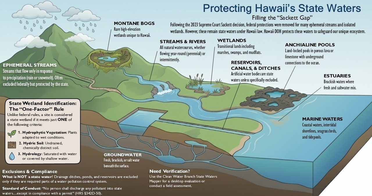
In response to the 2023 Supreme Court Sackett decision, the definition of “Waters of the United States” (WOTUS) was narrowed, excluding ephemeral streams and certain wetlands without continuous surface connections to navigable waters. As a result, these non-WOTUS state waters—including unique Hawaiian ecosystems—are no longer subject to the U.S. Army Corps of Engineers’ (USACE) federal permitting process. Although these waters remain protected under Hawaii Revised Statutes (HRS) HRS §342D-50, which prohibits unauthorized discharges into state waters, the Sackett decision created a gap in the permitting process where federal jurisdiction no longer applies. To address this gap, the Hawaii Department of Health (DOH) is providing guidance to clarify how state waters are identified and regulated. This guidance discusses the definition of state waters and helps the public determine whether state waters are present to ensure compliance with state water pollution control laws.
Background
Dredge and fill activities in WOTUS are regulated by the USACE federal Department of the Army (DA) permit, which also requires a Water Quality Certification (WQC) from the DOH. The WOTUS definition was amended by the U.S. Environmental Protection Agency (EPA) due to the 2023 Supreme Court Sackett decision. The new definition states ephemeral streams and other relatively non-permanent waterbodies and wetlands that do not have a continuous surface connection to a navigable waterway are no longer considered WOTUS. Activities that involve the discharge of dredged or fill materials into these non-WOTUS state waters will no longer have the protection of the DA permit. The revision to the WOTUS definition has created a gap in the State’s protection of these waters in situations where dredge or fill occurs in non-WOTUS state waters, or when a DA permit is not required.
Hawaii Revised Statutes (HRS) §342D-50 is a general water pollution prohibition that states: “No person, including any public body, shall discharge any water pollutant into state waters, or cause or allow any water pollutant to enter state waters except in compliance with this chapter, rules adopted pursuant to this chapter, or a permit, water quality certification, or variance issued by the director.” The State does not currently have a mechanism, resources, and staff to permit/authorize dredge and fill into state waters; therefore, our current policy is to prohibit all activities that fall under these circumstances using HRS §342D-50 Water Pollution Control Prohibition. For wastewater and stormwater discharges to non-WOTUS state waters, the CWB issues NPDES permits which may authorize the discharge.
Definitions
- State waters: all waters, fresh, brackish, or salt, around and within the State, including but not limited to coastal waters, wetlands, streams, rivers, drainage ditches, ponds, reservoirs, canals, ground waters, and lakes; provided that drainage ditches, ponds, and reservoirs required as a part of a water pollution control system are excluded (HRS §342D-1).
- Wetlands: land that is transitional between terrestrial and aquatic ecosystems where the water table is usually at or near the surface or the land is covered by shallow water. A wetland shall have one or more of the following attributes: (1) at least periodically the land supports predominantly hydrophytic vegetation; (2) the substratum is predominantly undrained hydric soil; or (3) the substratum is nonsoil (gravel or rocks) and is at least periodically saturated with water or covered by shallow water.
Description of State’s Wetlands
Hawaii’s wetlands include riverine wetlands, palustrine wetlands (marshes and bogs, including rare montane bogs), estuarine wetlands (swamps and mudflats), and marine wetlands (intertidal shorelines, seagrass beds, and tidepools). Hawaii is also host to landlocked systems in porous lava or limestone on coastal shorelines, known as anchialine pools (National Association of Wetland Managers, Hawaii State Wetland Program Summary, 2015).
Historically, Hawaii contained an estimated 59,000 acres of wetlands. Hawaii has lost over 12 percent of its original wetland acreage and over 30 percent of its natural lowland wetlands. The remaining wetlands cover less than three percent of Hawaii’s surface area and provide important functions, including habitat for plant and animal species endemic to the Hawaiian Islands. Hawaii’s unique hydrological conditions—heavy rainfall, porous volcanic soil, and steep terrain—create wetlands that are different from those found in any other region of the United States (National Association of Wetland Managers, Hawaii State Wetland Program Summary, 2015).
Hawaii’s surface water quality standards definition of “wetlands” is “land that is transitional between terrestrial and aquatic ecosystems where the water table is usually at or near the surface or the land is covered by shallow water. A wetland shall have one or more of the following attributes: (1) at least periodically the land supports predominantly hydrophytic vegetation; (2) the substratum is predominantly undrained hydric soil; or (3) the substratum is nonsoil (gravel or rocks) and is at least periodically saturated with water or covered by shallow water. Wetlands may be fresh, brackish, or saline and generally include swamps, marshes, bogs, and associated ponds and pools, mud flats, isolated seasonal ponds, littoral zones of standing water bodies, and alluvial floodplains.” These are to include several coastal wetlands, elevated wetlands, and low wetlands (National Association of Wetland Managers, Hawaii Wetland Water Quality Standards).
Description of State’s Ephemeral Streams
Ephemeral streams are streams that only flow in response to precipitation, such as rain or snowmelt, and for a short time after the event (Learn more about streams from USEPA). They are above the groundwater table and are most common in arid areas. Hawaii’s volcanic topography and tropical climate can create unique situations where ephemeral streams play a significant role in water flow and erosion, making their management particularly important for local ecosystems. Ephemeral streams and other relatively non-permanent waterbodies and wetlands—often referred to as Sackett-gap waters—are no longer considered WOTUS if they lack a continuous surface connection to a navigable waterway. Given this, DOH is seeking to clarify regulation of these Sackett-gap waters as they are still considered state waters and are protected under the HRS §342D-50.
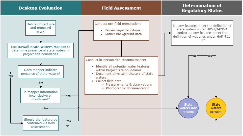
Desktop Evaluation
The recent changes to WOTUS have shifted the regulatory landscape, prompting questions about where state authority applies. In an effort to use time and resources efficiently, this section provides guidance for identifying Hawaii state waters within a proposed project site from a desktop environment. While a desktop approach is limited by a variety of factors, including data availability and accuracy, it serves as a crucial first step in determining the presence of state waters as defined by HRS §342D-1.
In many cases, this procedure may provide sufficient information to confirm whether state waters are present and to identify their approximate extent. When ambiguity remains, field activities or additional analyses may be necessary to confirm findings.
Identify the Project Site Boundaries and Proposed Work Before conducting the desktop analysis, the applicant should ensure that the project site boundaries, as well as the proposed work within this footprint, are well-defined and consistent throughout the desktop analysis.
- Proposed work refers to the specific activities planned within the project site, such as construction, drainage modifications, or infrastructure installations.
- Project site refers to the geographic area in which the proposed work will occur, as defined by the applicant.
The project site should align with the official boundaries established in permit applications, design plans, or regulatory approvals. For example, if the application delineates a 10-acre project site, these same boundaries should be maintained throughout the desktop analysis. If modifications to the proposed work or other project components lead to alterations in the original project site, the desktop analysis of state waters should be updated accordingly to reflect the revised footprint.
Clean Water Branch’s State Waters Mapper
To assist in the desktop identification of state waters, the Clean Water Branch of the Hawaii Department of Health has developed a mapping application to summarize spatial information relevant to Hawaii state waters within a user-defined search area. These resources have been identified using publicly available geospatial datasets and are intended to support planning, permitting, and environmental review processes. While this tool is based on reputable data, it should not be considered exhaustive or definitive. Absence of mapped features in this report does not confirm their absence on the ground. Mapped limits are approximate and do not constitute a final determination. Field verification and consultation with the appropriate state or local agencies are recommended for any regulatory, ecological, or development-related decision-making. For additional guidance or questions regarding the data sources or interpretation of this report, please contact the Clean Water Branch.
Go to Clean Water Branch’s State Waters Mapper
Field Assessment of State Waters
In the event a desktop assessment proves inconclusive, project proponents should conduct a field assessment to determine the presence of state waters. DOH has provided the guidance below to assist in the identification of state waters in the field.
Pre-Field Preparation
- Review Legal Definition
- State waters include:
- All waters (fresh, brackish, or salt) on or beneath the surface.
- Natural or artificial watercourses, lakes, ponds, reservoirs, wetlands, streams, rivers, drainage ditches, and canals.
- Note that while groundwater is also considered state waters, this guidance process does not address groundwater. A separate assessment will need to be conducted to assess presence and potential impacts to groundwater resources.
- State waters do not include: Drainage ditches, ponds, and reservoirs required as part of a water pollution control system. (HRS §174C-3)
- State waters include:
- Gather Background Data
- Topographic maps, aerial imagery, and GIS layers (e.g., Hawaii Wetlands GIS, USGS hydrography).
- Stream and wetland inventories (Hawaii Stream Assessment, DAR Freshwater Database).
Site Reconnaissance
- Identify Potential Water Features
- Streams (perennial, intermittent, ephemeral).
- Wetlands (palustrine, estuarine, anchialine pools).
- Ponds, reservoirs, canals, drainage ditches.
- Groundwater indicators (springs, seeps).
- Document Physical Indicators
- Channel morphology, bank features, substrate type.
- Evidence of flow (bed and bank, water marks, debris lines).
- Vegetation: hydrophytic species for wetlands.
- Soil: hydric indicators for wetlands.
Apply Hawaii Criteria
- Confirm if the feature meets state definitions:
- Does it hold or convey water – whether fresh, brackish, or salt – even intermittently?
- Is it natural or artificial and not excluded by law?
- Does the feature connect to or have the potential to affect other state waters?
- For wetlands, apply Hawaii WQS definition:
- Is it in a transitional land-water zone with hydrophytic vegetation, hydric soils, or saturation indicators (HAR §11-54)?
Collect Field Data
- Measurements and Observations
- GPS coordinates and mapping of feature boundaries.
- Water depth, width, and flow conditions (if present).
- Soil sampling for hydric indicators (wetlands).
- Vegetation survey for dominant species.
- Photographic Documentation
- Overview and close-up shots of key indicators such as hydrology, wetland vegetation, or hydric soils.
Determine Regulatory Status
- If feature meets HRS 174C or HRS 342D definition, classify as state water.
- For wetlands, confirm applicability of HAR 11-54 water quality standards.
Guidance for the Identification of State Waters
Field Assessment Resources
Several Hawaii-specific resources exist in order to execute this. The U.S. Army Corps of Engineers (USACE) has developed a regional supplement to their Wetland Delineation Manual specific to Hawaii and the Pacific Islands region. This regional supplement can be utilized by qualified wetland scientists to identify areas that exhibit wetland hydrology, vegetation, and soils. Note that, given Hawaii’s definition of state waters and wetlands below, only one wetland indicator, as defined by USACE’s regional supplement, would need to be identified to be considered a wetland by the state of Hawaii.
- State waters: all waters, fresh, brackish, or salt, around and within the State, including but not limited to coastal waters, wetlands, streams, rivers, drainage ditches, ponds, reservoirs, canals, ground waters, and lakes; provided that drainage ditches, ponds, and reservoirs required as a part of a water pollution control system are excluded (HRS §342D-1).
- Wetlands: land that is transitional between terrestrial and aquatic ecosystems where the water table is usually at or near the surface or the land is covered by shallow water. A wetland shall have one or more of the following attributes: (1) at least periodically the land supports predominantly hydrophytic vegetation; (2) the substratum is predominantly undrained hydric soil; or (3) the substratum is nonsoil (gravel or rocks) and is at least periodically saturated with water or covered by shallow water.
Additionally, USACE has developed the Supplemental Data for Remote Sensing methodology, which provides guidance for analyzing wetland hydrology using satellite imagery. This approach is designed to support the identification of wetland characteristics such as saturation and inundation and can be applied to areas where field verification is limited or unavailable. The methods outlined in this document are applicable across the United States, including Hawaii, and are particularly useful for evaluating hydrologic indicators in support of wetland delineation.
USACE has also developed the National Ordinary High Water Mark (OHWM) Field Delineation Manual for Rivers and Streams which can be used to define the lateral extent of non-tidal aquatic features in the absence of adjacent wetlands throughout the United States, including Hawaii. The methods contained in the OHWM manual are applicable for both streams and lakes, but the focus of this manual is presenting a method for delineating the OHWM in streams.
The EPA has also developed assessment methods for determining if streams are perennial, intermittent, or ephemeral utilizing regional streamflow duration assessment methods. Currently, this regional streamflow assessment method is not available in Hawaii but it may become available in future years. Please check the Regional Streamflow Duration Assessment Methods for future updates.

- Current Water Quality Advisories
- Current Public Notices and Updates
- About CWB
- History and Mission Statement
- Protecting Hawaii’s State Waters
- Contact Us
References and Public Records
- CWB Standard Comments
- Water Quality References
- State Waters Mapper
- Workshop Presentations
- Water Pollution Control (WPC) Viewer for Public Access to Government Documents
- Post-2018 Final Individual NPDES Permits
- Request to Access a Government Record Form
NPDES Permitting
- NPDES Permits and How to Apply
- Permitting FAQs
- Forms
- e-Permitting Portal
- NPDES General Permits
- Standard Individual NPDES Permit Conditions
- Industrial Storm Water and No Exposure Exclusion
- Dental Amalgam Rules
Section 401 Water Quality Certification (WQC)
- Section 401 WQC
- Blanket Section 401 WQC
- Vessel General Permit (VGP)
- Small Vessel General Permit (sVGP)
Hawaii Administrative Rules (HAR)
- 11-53, Section 401 Water Quality Certifications
- 11-54, Water Quality Standards
- 11-55, Water Pollution Control
- 11-56, Nonpoint Source Pollution Control
Polluted Runoff Control Program
- About the Polluted Runoff Control Program
- 319 Grant Program
- Watershed-Based Plans
- Plans and Reports
- Agriculture
- Wastewater
- What You Can Do
Water Quality Monitoring