USACE Residential Confirmatory Soil Sampling
Air | Ash and Debris | Beach Sand | Coastal Sediment | Coastal Waters | County Parks | West Maui TDS Site | Soil
Maui Wildfire Data: Soil
USACE Confirmatory Soil Sampling – Residential
USACE conducted confirmatory soil sampling for the August 2023 wildfires that affected properties in Kula; Lahaina; and Makawao, Maui—areas where USACE completed debris removal activities. USACE conducted this soil sampling to evaluate levels of metals associated with debris and ash after debris removal. The sampling was conducted to confirm that it would be safe for residents to return to their properties and begin rebuilding.
The sampling and analyses were conducted in accordance with the Department of Health (DOH) Hazard Evaluation and Emergency Response (HEER) Technical Guidance Manual (TGM).
Please be sure to read the entirety of the subsections below and follow the instructions to review soil sampling results on the simplified look-up table below and understand how to interpret the results. PDF files of the entire datasets are available for download at the links provided below.
Please contact the DOH HEER Office at (808) 586-4249 for further assistance in understanding these results.
Accessing the Data
The number of requests to share soil sampling results has increased over time. In response, DOH and USACE are posting the following dataset for efficient access, providing the public with ease of viewing and downloading the data:
- A simplified look-up table (below) displaying the TMK (Tax-Map-Key), property address, city, sample ID, sample date, analytical results, and applicable cleanup goals.
- A downloadable PDF pivot table with additional data fields and analytical results organized by analyte.
- A downloadable PDF version of the full dataset showing all rows and columns reported by the laboratory, including laboratory methods, quality assurance information, tracking information, and other information. This dataset also includes the cleanup goals, as defined and presented below.
Sampling results are presented for each property and compared to “cleanup goals.” Cleanup goals refer to Environmental Action Levels (EALs), which are screening values for human health. These EALs are summarized and explained in more detail below.
Understanding the Tables
Field Descriptions – Simplified Look-Up Table
- TMK: The Tax-Map-Key location where the sample was collected.
- Address: The physical address where the sample was collected.
- City: The city where the sample was collected.
- SMP_ID: The identification number (ID) of the sample collected. Each sample has an ID. For each TMK and address, there are multiple sample IDs. This is because DOH uses a sampling approach to collect many different samples from each location (referred to as “decision units”). The format of the sampling ID is as follows: [city where sample was collected] – [12-digit TMK] – Descriptor. The descriptors are as follows:
- -A1, -A2, etc.: The decision unit where the sample was collected.
- -R: Re-scrape samples collected at the same site. These samples are the final samples taken and will be highlighted in yellow.
- -T1/T2/T3: Field triplicate, which is used for quality assurance.
- -L1/L2/L3: Laboratory replicates, which are used for quality assurance.
- -AVG: Average of the quality assurance samples (not the property sample).
- SMP_DT: The date the sample was collected.
- ANALYTE: The parameter being sampled.
- LAB_RESULT: The analytical sampling result.
- UNIT: The unit of measurement for the sample, e.g., mg/kg = milligrams/kilogram.
- RES_EAL: The residential EAL for the analyte.
- COMM_IND_EAL: The commercial/industrial EAL for the analyte.
- EXCEED_CRITERIA: A sampling result above the identified EAL, as indicated by a “Y” = Yes; “Y_CommInd” = Yes, Commercial/Industrial. Blank cells indicate no exceedance.
Interpreting Sample Results
The sample result shown in the “LAB_RESULT” column in the table below can be compared to the respective DOH Environmental Action Level (EAL) shown in columns “RES_EAL” and “COMM_IND_EAL.”
Hawaii DOH establishes EALs for a wide variety of land uses (e.g., residential or industrial), proximity to drinking water or surface water, and other potential exposure and toxicity considerations. These EALs may also be adjusted for project-specific considerations. EALs are threshold levels for contaminants in soil, water, or air that indicate whether further investigation or action is necessary to protect human and environmental health. An EAL represents a level below which no adverse health effects are expected; sampling results that exceed an EAL show that contamination may warrant further evaluation or a more detailed risk assessment to determine if remediation is necessary.
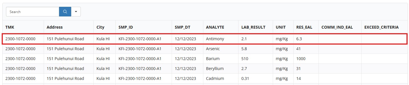
The image below provides an example screenshot of the simplified look-up table. The sampling result for antimony is shown in the “LAB_RESULT” column. The sampling result is 2.1 mg/kg, which is below the residential EAL (6.3 mg/kg). The “EXCEED_CRITERIA” column is blank because the sample result did not exceed the EAL.
If the laboratory result for a property is below the respective EAL, there is no significant health risk. Some properties may have multiple laboratory results (for example, a sample with the re-scrape ID, “-R”, shows that the property was scraped twice). In a few cases, the sampling result was higher for samples collected at a lower depth. This is likely due to the changing natural background or a non-fire-related source. If the result for the re-scraped sample was above the EAL, the property completion report should indicate applicable rebuild instructions, if any.
For this USACE confirmatory sampling, most EALs are the same as DOH EALs for unrestricted use over drinking water sources and near surface water sources. Some standard residential unrestricted use EALs have been modified to reflect site-specific exposure conditions. For example:
- The EAL of 24 mg/kg for arsenic was modified by DOH to incorporate the bioavailability of arsenic for human receptors. The modified EAL (carcinogenic effect) of 41 mg/kg for arsenic has been identified as the cleanup goal.
- The cleanup goal of 156 mg/kg for cobalt is based on concentrations presented in Cobalt Content of Typical Soils and Plants of the Hawaiian Islands (Fujimoto and Sherman, 1960) (opens in a new tab).
- The cleanup goal of 767 mg/kg for nickel is based on the upper background threshold value for nickel presented in Table 6 of Hawaiian Islands Soil Metal Background Evaluation Report (HEER, 2012) (opens in a new tab).
All values have been approved by DOH. The EALs for the private property debris removal program confirmatory soil sampling are summarized below:
USACE Confirmatory Soil Sampling EALs
| Analyte | Residential EAL1 (mg/kg) | Commercial/Industrial EAL1 (mg/kg) |
|---|---|---|
| Antimony | 6.3 | 82 |
| Arsenic | 41 | 95 |
| Barium | 1,000 | 2,500 |
| Beryllium | 31 | 150 |
| Cadmium | 14 | 72 |
| Chromium | 1,100 | 1,100 |
| Cobalt | 156 | 156 |
| Copper | 3,100 | 3,100 |
| Lead | 200 | 800 |
| Molybdenum | 78 | 1,000 |
| Nickel | 767 | 767 |
| Selenium | 78 | 1,000 |
| Silver | 78 | 1,000 |
| Thallium | 0.78 | 10 |
| Vanadium | 770 | 770 |
| Zinc | 4,700 | 4,700 |
1 EALs are the cleanup goals, with some standard residential unrestricted use EALs modified to reflect site-specific exposure conditions, as discussed above.
For more EAL-related information, please visit the DOH HEER Office website:
HAZARD EVALUATION & EMERGENCY RESPONSE (HEER) OFFICE Environmental Hazard Evaluation and Environmental Action Levels (opens in a new tab)
For questions on how to interpret these data and understand if there are any health risks, please contact the DOH HEER Office at (808) 586-4249. They will answer your questions and address any concerns.
Searchable Look-Up Table
Users can find the sampling results for different properties by searching by the property address or the TMK in the search box below. If using TMK, it must be entered in a 12-digit format (e.g., a TMK of (1)2-3-4-056:789 would be entered as 1234-5678-9000). Users can also download the pivot table and full dataset. The search will return all results for that TMK, not including QA/QC samples. If a re-scrape of the property was required, re-scrape results, which are the soil conditions remaining at the property, are highlighted in yellow.