West Maui TDS Site
Air | Ash and Debris | Beach Sand | Coastal Sediment | Coastal Waters | County Parks | West Maui TDS Site | Soil
Maui Wildfire Data: West Maui Temporary Debris Storage (TDS) Site
TDS Site page text and figures are current through December 29, 2025. Access the most recent data.
Debris removal in Lahaina was a critical step in the larger wildfire recovery efforts. Debris removal involved clearing and disposing of materials and waste burned in the fire, some of which may have been hazardous to human health. It involved a controlled process to ensure the safe collection, removal, transportation, and storage of debris so that people could safely re-enter their neighborhoods and rebuild.
Sampling data collected to date show that the West Maui Temporary Debris Storage Site did not release harmful substances into the environment at levels of health concern.
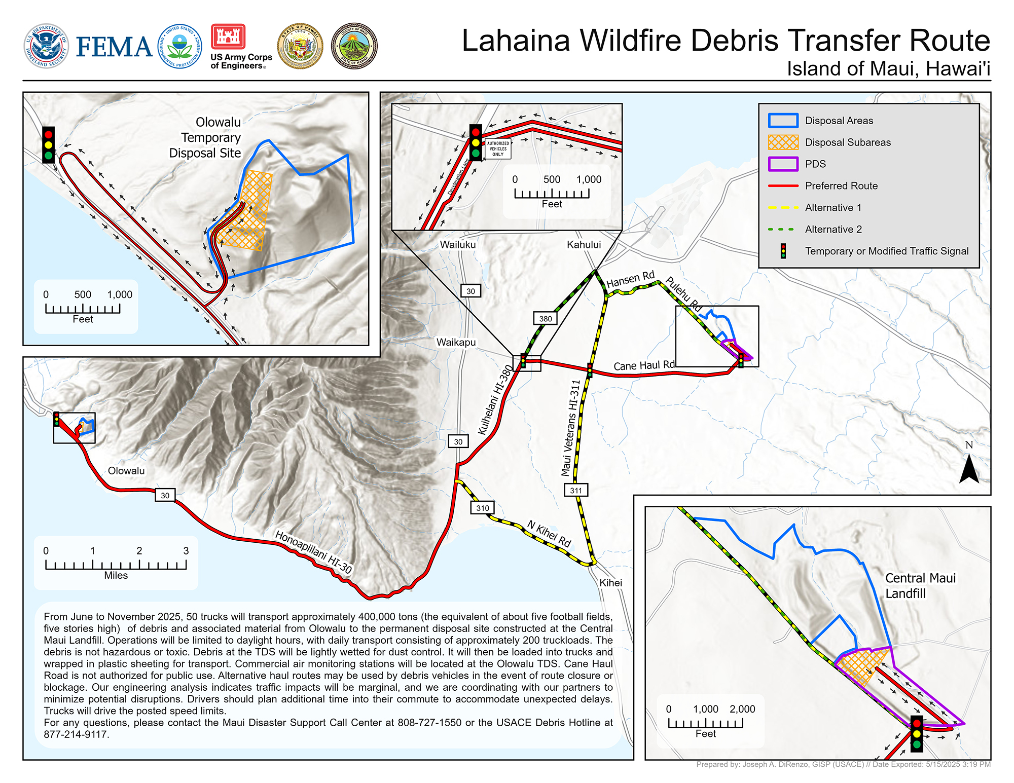
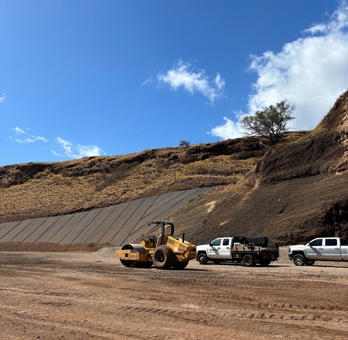
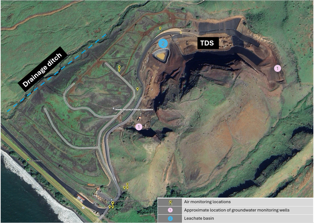
The West Maui Temporary Debris Storage (TDS) Site, located in Olowalu, received over 380,000 tons of ash and debris from Lahaina from January 2024 to January 2025. This site was designed to protect soil, groundwater, and coastal waters from any environmental impact from ash and debris. As of January 2025, the TDS Site no longer accepted debris and ash from commercial or residential properties in Lahaina.
Transfer to the Permanent Disposal Site (PDS)
The West Maui TDS Site served as a temporary site for ash and debris disposal until a Permanent Disposal Site (PDS) could be constructed. On February 28, 2024, Mayor Richard Bissen announced that the PDS would be at the Central Maui Landfill. The PDS needed to be constructed and operational prior to ash and debris transfer from the TDS Site to the PDS. The County of Maui and USACE developed a plan with processes and procedures for the safe loading, transportation, and disposal of ash and debris at the PDS, as well as closure of the TDS Site. The transfer process began in mid-June 2025 and continued until November 2025. Procedures included the following:
- After Lahaina cleanup efforts were completed, the TDS Site was temporarily closed and secured.
- Ash and debris were loaded out and secured with polyethylene plastic liners with additional tarps during transport by truck to the PDS.
- Trucks leaving the loadout area passed across mats designed to remove debris and prevent tracking out of material along the access road.
- Earthen cover was replaced daily to control dust at the TDS Site and the PDS.
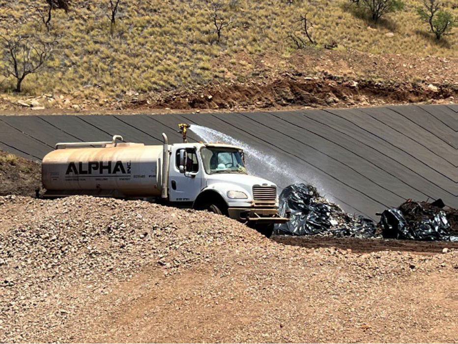
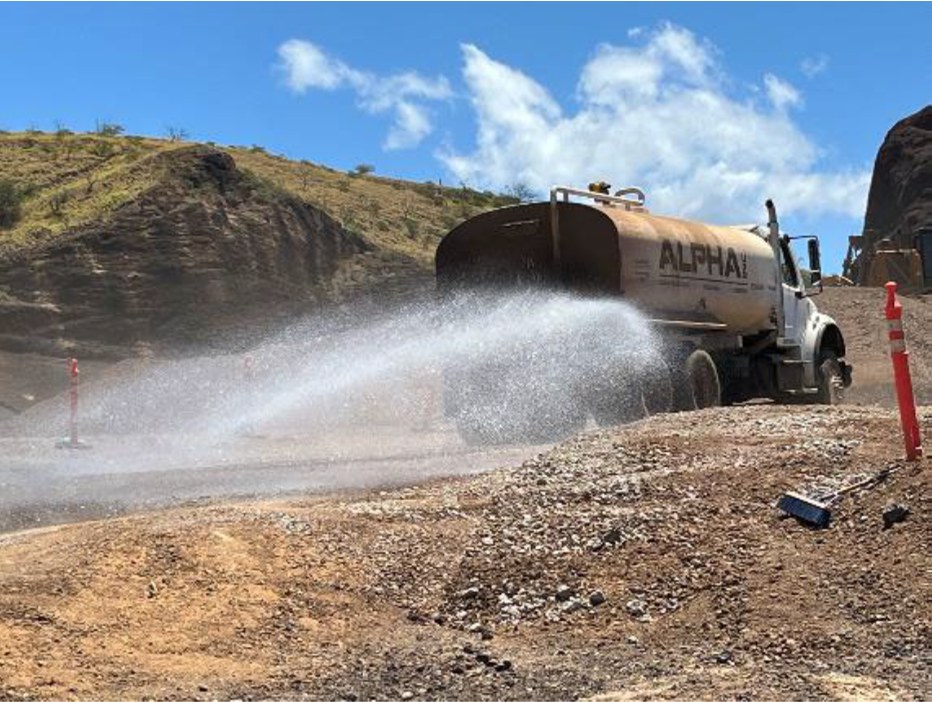
- Water trucks were used to control dust during excavation, loading, and loadout.
- The County of Maui worked with DOH and USACE to monitor both the PDS and the TDS Site as transfer to the PDS took place, including dust monitoring and perimeter air monitoring. Current air monitoring reports are available for download.
- Leachate monitoring, stormwater diversion, and groundwater monitoring took place throughout TDS Site closure operations.
- After the debris transfer from the TDS Site to the PDS was completed, the protective liner at the TDS Site was removed and soil sampling was conducted to ensure no impact on the land or public health. Post-use data were well below action levels and showed no impact to the site.
- The groundwater monitoring wells were properly decommissioned and
removed on December 18 and 19, 2025. - TDS Site areas were graded and restored to as close to original conditions as possible as of December 19, 2025, and best management practices and run-on/runoff management will be maintained as necessary.
For more information on this process, the public can contact the County of Maui (808-270-7297). Maui Recovers provides additional information about the TDS–PDS Transfer and Closure Plan (opens in a new tab).
TDS Site Monitoring
As transfer to the PDS took place, the U.S. Army Corps of Engineers (USACE) continued to monitor and carefully manage debris at the TDS Site. USACE, DOH, and partners collected environmental samples to ensure that the debris was properly managed. The County of Maui’s Bill 120 (opens in a new tab) required TDS Site operators to conduct monitoring and publish the sampling results in a report to the public every 90 days. The monitoring checked whether harmful substances at the TDS Site were entering the air, the groundwater beneath the site, or the surface water that ran through the TDS Site.
USACE took the following steps to protect human health and ensure that debris and ash removed from Lahaina did not pollute the air and water resources (stormwater, surface waters, and groundwater) around the TDS Site and the PDS:
- Prohibiting large truck dumping when wind speeds were high.
- Using water sprays on high-dust days to keep ash out of the air.
- Covering collected material with clean soil or volcanic rock to reduce windblown dust.
- Setting truck speed limits on dirt roads.
- Diverting stormwater around the TDS Site and the PDS to prevent it from contacting ash and debris. The storm drains throughout the site had inlet protection to prevent harmful substances in stormwater from entering the basin.
- Collecting leachate (liquid, mostly stormwater, that has contacted the active ash/debris storage area) rather than releasing it into the environment. Stormwater that fell on the active TDS area either evaporated, was absorbed by the ash and debris, or flowed as leachate to a collection basin (the leachate basin). A thick liner beneath the leachate basin prevented the leachate from seeping into underlying soils. The basin size and location did not allow the leachate to mix with stormwater, so the leachate did not reach surface water. The leachate basin was designed to hold over 1 million gallons—much more than the amount of leachate that was expected to be generated. Leachate collected in the basin did not flow outside the TDS Site.
- Constructing the TDS Site in a location that was downgradient (below) public drinking water sources to mitigate any potential for contamination of drinking water sources from the TDS Site.
Below is a summary of the TDS Site environmental monitoring data provided by USACE.
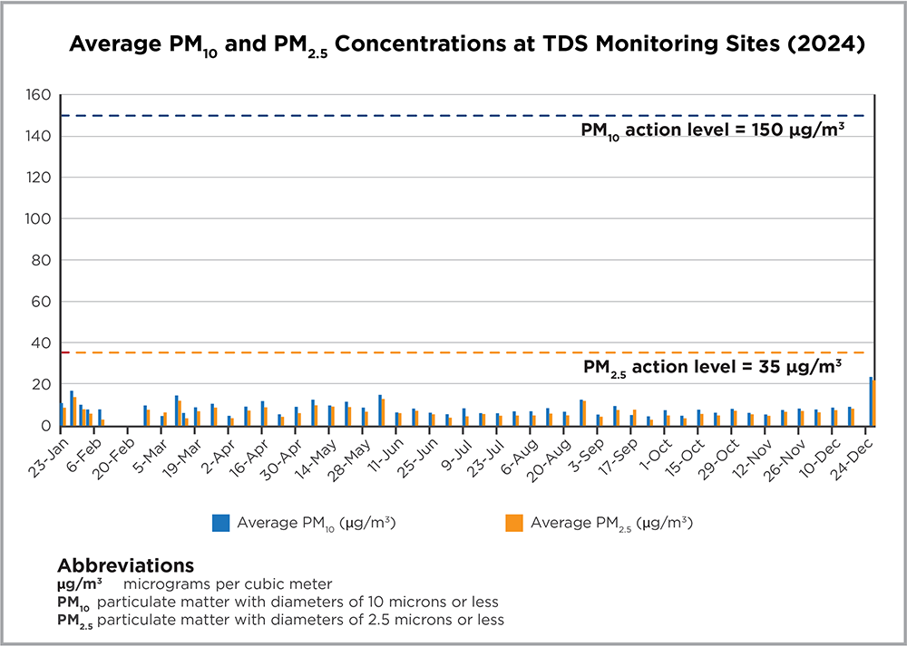
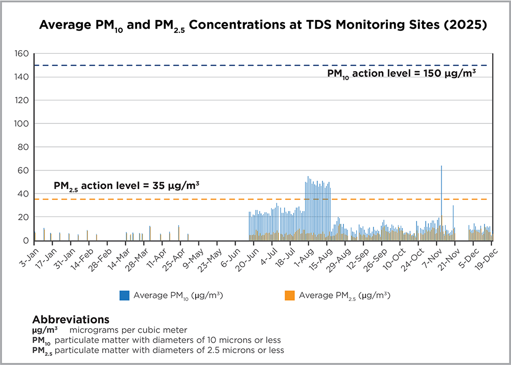
TDS Site Air Monitoring
USACE contractors used air monitors to measure airborne particles (both PM2.5 and PM10) near debris removal sites. The number and locations of air monitors at the TDS Site varied based on weather conditions and operations. USACE’s air monitoring data for 2024 and 2025 are shown in Figures 4 and 5. The figures show particulate matter concentrations averaged between the two monitoring sites around the TDS Site. Particulate matter concentrations at individual monitoring sites varied, with some higher and some lower than the averages shown. Air monitoring was paused from April 30, 2025, to June 17, 2025, when the TDS Site was temporarily closed and no site operations were taking place. Monitoring resumed when transfer to the PDS began, and daily samples were taken through the completion of transfer and closure operations in November 2025. Air monitoring was paused again from November 21–30, 2025, and then resumed until the completion of the project. Figures 4 and 5 show that all measurements for both PM2.5 and PM10 were below their respective action levels set for operating the TDS Site (35 μg/m3 for PM2.5 and 150 μg/m3 for PM10).
USACE’s site monitoring reports are available for download.
USACE also provided air monitoring of the TDS to PDS transfer.
DOH provides real-time air monitoring at locations throughout the Olowalu community. These data are posted in near-real time to https://fire.airnow.gov/. All DOH measurements of airborne fine particles (PM2.5) in the Olowalu community to date indicate that airborne particles have not reached levels of health concern. The Air page includes further discussion of results and associated sampling data.
TDS Site Leachate Sampling
USACE sampled and measured the amounts of potentially harmful substances in the leachate after storm events of 1 inch or greater. Results of parameters of the greatest concern from sampling are shown below (Table 1), with full results available for download. The final leachate sample was taken on October 9, 2025, and the leachate basin was removed in November, along with the remaining leachate and sediment, as part of TDS closure operations.
The presence of potentially harmful substances in the leachate basin was not a public health concern because people did not enter the basin or drink the water, and the site was not above a groundwater source of drinking water and was downgradient (downhill) of public water supplies.
The leachate basin was lined and undamaged and, as such, there has been no evidence of leachate leaking to underlying soils or groundwater. Still, USACE installed wells to monitor the groundwater upgradient (uphill) and downgradient (downhill) from the TDS Site to confirm that leachate did not enter the groundwater.
Note that the “baseline stormwater” sample data shown in Table 1 was from stormwater that had collected in the leachate basin, not leachate from the TDS Site, as discussed below.
Parameters | Units | Sample Date | ||||||||||||||||
|---|---|---|---|---|---|---|---|---|---|---|---|---|---|---|---|---|---|---|
| 1/11/2024 (baseline, stormwater) | 1/30/2024 (leachate) | 2/8/2024 (leachate) | 2/13/2024 (leachate) | 2/20/2024 (leachate) | 4/15/2024 (leachate) | 5/20/2024 (leachate) | 2/3/2025 (leachate) | 10/9/2025 (leachate)1 | ||||||||||
| Arsenic | mg/L | <0.010 | 0.0027 | — | 0.0027 | <0.16 | ND | ND | ND | ND | ||||||||
| Cobalt | mg/L | 0.026 | 0.0033 | — | 0.0019 | 0.4 | 0.0028 | 0.002 | NS | NS | ||||||||
| Copper | mg/L | 0.042 | 0.007 | — | 0.0047 | 0.23 | ND | ND | NS | NS | ||||||||
| Lead | mg/L | <0.010 | 0.00096 | — | 0.0042 | <0.071 | ND | ND | ND | ND | ||||||||
| Dioxins / Furans (2,3,7,8-TCDD) | pg/L | NS | — | — | <1.9E-09 | <2.0E-09 | ND | <2.1E-09 | NS | NS | ||||||||
1As of 12/15/2025, the most recent round of leachate sampling occurred on 10/9/2025
<: less than
ND: non-detect
NS: not sampled
TDS Site Stormwater Sampling
In early January 2024, over 3 inches of rain fell in less than 24 hours at the empty TDS Site. The site was under construction and debris had not yet been stored at the site. USACE sampled the rainwater from the storm that had collected in the leachate basin on January 11, 2024, the results of which are shown in the table as “(baseline stormwater).”
USACE sampled the leachate basin periodically and sampled the basin monthly if a rainfall event of more than 1 inch took place during the month. The latest monitoring results are presented in Table 1.
TDS Site Surface Water Sampling
In addition to USACE site-specific monitoring, DOH is collecting coastal water samples near the TDS Site. These data show that the levels of fire-related substances present in surface water do not pose a risk to human health. Based on the results of recent sampling, DOH may conduct additional water quality sampling after closure of the TDS Site.
TDS Site Groundwater Sampling
USACE installed two temporary groundwater monitoring wells uphill (Monitoring Well 01) and downhill (Monitoring Well 02) of the TDS Site. Well construction began during June 2024 and was completed on July 10, 2024. Monitoring Well 01 had a depth of 328.92 feet, and Monitoring Well 02 had a depth of 158.53 feet. USACE sampled and analyzed the groundwater for similar potential contaminants of concern as leachate. USACE also compared the downhill well sample results to the uphill well sample results to identify if fire-related substances were entering the groundwater from the TDS Site. USACE collected groundwater samples in July, October, and December of 2024, as well as in February, May, August, and November of 2025. These data are presented in Table 2. In November 2025, USACE collected the final groundwater sample; these data are shown in Table 2. The groundwater monitoring results indicate no fire-related substances are reaching groundwater.
Table 2. USACE TDS Site groundwater monitoring results for various parameters (µg/L) collected in 2024 and 2025 (download full data).
Well Information | Sample Date | Parameter (μg/L) | ||||||
|---|---|---|---|---|---|---|---|---|
| Arsenic | Cobalt | Copper | Lead | |||||
| 7/7/2024 | ND | 0.84 | 2.5 | ND | ||||
| 10/8/2024 | ND | 1.9 | 3 | 0.3 | ||||
| Uphill | 12/8/2024 | 1.7 | 0.84 | 2.5 | 0.47 | |||
| (Monitoring Well 01) | 2/8/2025 | 1.7 | 0.54 | 0.67 | 0.17 | |||
| 5/5/2025 | 0.74 | 0.69 | 0.93 | 0.5 | ||||
| 8/5/2025 | 1.7 | 0.23 | 0.86 | 0.24 | ||||
| 11/18/2025 | 1.7 | 0.28 | 0.87 | 0.24 | ||||
| 7/7/2024 | ND | 0.19 | 0.72 | ND | ||||
| 10/8/2024 | 1.1 | 0.41 | 1 | 0.76 | ||||
| 12/4/2024 | 1.7 | 0.17 | 0.9 | 0.25 | ||||
| Downhill | 2/8/2025 | 1.7 | 0.4 | 1.2 | 3.2 | |||
| (Monitoring Well 02) | 5/5/2025 | 1.7 | 0.17 | 1.1 | 0.5 | |||
| 8/5/2025 | 1.7 | 0.4 | 0.9 | 0.25 | ||||
| 11/18/2025 | 1.7 | 0.4 | 0.9 | 0.22 | ||||
ND: non-detect
TDS Site Soils Sampling
In November 2023, before construction of the TDS Site and installation of the protective liner, soil samples were taken from five decision units (DUs) to establish baseline soil conditions at the site. Results from this pre-construction sampling are shown in Table 3. After all debris was transferred from the TDS Site in November 2025, the protective liner was removed, and the soil was sampled again. Pre- and post-use data were compared to determine whether debris storage had any impact on the soil around the site and whether any further action was necessary before closure and grading.
Post-use sampling showed that all substance levels were well below actions levels that would indicate public health concern, and that the debris had no impact on surrounding soil or groundwater. Therefore, no additional action was necessary, and final grading and closure of the TDS Site could proceed safely.
Parameters | Action Levels1 | DU-1 (mg/kg) | DU-2 (mg/kg) | DU-3 (mg/kg) | DU-4 (mg/kg) | DU-5 (mg/kg) | ||||||||||
|---|---|---|---|---|---|---|---|---|---|---|---|---|---|---|---|---|
| Pre | Post | Pre | Post | Pre | Post | Pre | Post | Pre | Post | |||||||
| Antimony | 6.3 | 0.18 | 0.06 | 0.19 | 0.08 | 0.19 | 0.06 | 0.19 | 0.08 | 0.19 | 0.1 | |||||
| Arsenic | 41 | 1.4 | 0.96 | 1.5 | 1.04 | 0.73 | 0.91 | 0.58 | 0.74 | 0.94 | 0.71 | |||||
| Barium | 1000 | 15 | 49 | 15 | 56 | 32 | 51 | 40 | 50 | 39 | 72 | |||||
| Beryllium | 31 | 0.56 | 1.1 | 0.66 | 1.02 | 0.6 | 1.07 | 0.75 | 0.87 | 0.66 | 1.45 | |||||
| Cadmium | 17 | 0.09 | 0.08 | 0.13 | 0.08 | 0.09 | 0.08 | 0.09 | 0.07 | 0.1 | 0.09 | |||||
| Chromium | 1100 | 0.81 | 14.7 | 1 | 20 | 0.84 | 18.7 | 0.53 | 13 | 7 | 1.3 | |||||
| Cobalt | 156 | 1.1 | 7.1 | 1.4 | 9.9 | 1.2 | 8.6 | 1.2 | 6.2 | 3 | 1.8 | |||||
| Copper | 3100 | 1.6 | 10 | 4.9 | 14.7 | 1.6 | 17.8 | 0.86 | 8.4 | 4.9 | 1.8 | |||||
| Lead | 200 | 2.1 | 1.57 | 1 | 2.1 | 1.1 | 1.73 | 0.97 | 1.51 | 2.2 | 1.55 | |||||
| Molybdenum | 78 | 0.51 | 0.6 | 0.54 | 0.73 | 0.5 | 0.68 | 0.67 | 0.66 | 0.69 | 0.76 | |||||
| Nickel | 767 | 0.79 | 14.7 | 1 | 19 | 0.92 | 15.7 | 0.53 | 11.6 | 9 | 1.75 | |||||
| Selenium | 78 | 4.9 | 0.13 | 5.4 | 0.05 | 3.6 | 0.11 | 3.2 | 0.09 | 3.7 | 0.11 | |||||
| Silver | 78 | 0.05 | 0.04 | 0.02 | 0.05 | ND | ND | 0.05 | 0.06 | 0.047 | 0.075 | |||||
| Thallium | 0.78 | ND | ND | ND | ND | ND | ND | ND | ND | ND | ND | |||||
| Vanadium | 770 | 1.2 | 30.7 | 1.4 | 43.3 | 1.2 | 38.3 | 1 | 26.4 | 8.5 | 3.25 | |||||
| Zinc | 4700 | 48 | 58.7 | 51 | 63.7 | 44 | 55 | 49 | 50.2 | 52 | 61 | |||||
| Mercury | 4.7 | ND | ND | ND | ND | ND | ND | ND | ND | ND | ND | |||||
| Diesel Range Organics | 180 | ND | ND | ND | ND | ND | ND | 30 | 7.74 | 16 | 8.9 | |||||
| Gasoline Range Organics | 100 | ND | ND | ND | ND | ND | ND | ND | ND | ND | ND | |||||
| Oil Range Organics | 500 | 18 | 14.7 | 26 | 27.7 | 30 | 60.3 | 29 | 22.9 | 30 | 22.5 | |||||
DU = decision unit
ND = non-detect
1Action levels are based on Hawaii Environmental Action Levels (EAL), Table A-2, Final EAL, with the following exceptions, as modified by DOH:
– The level for arsenic of 41 mg/kg incorporates the bioavailability of arsenic for human receptors.
– The level for cobalt of 156 mg/kg is based on concentrations presented in “Cobalt Content of Typical Soils and Plants of the Hawaiian Islands,” Fujimoto and Sherman, 1950.
– The level for copper of 3100 mg/kg is based on the residential direct- exposure EAL presented in Table I-1, Final EAL, with Hazard Quotient = 1.
– The level for nickel of 767 mg/kg is based on the upper background threshold value for nickel presented in Table 6, “Hawaiian Islands Soil Metal Background Evaluation Report,” May 2012.
– The level for zinc of 4700 mg/kg is based on the residential direct- exposure EAL presented in Table I-1, Final EAL, for non-carcinogens.
What Do the Data Tell Us?
The sampling data collected to date confirm that TDS Site operations did not release harmful substances into the environment at levels of health concern. The final grading and restoration of the TDS Site has concluded as of December 19, 2025. Full data on TDS Site sampling are available for download.
Air | Ash and Debris | Beach Sand | Coastal Sediment | Coastal Waters | County Parks | West Maui TDS Site | Soil