Coastal Sediment
Air | Ash and Debris | Beach Sand | Coastal Sediment | Coastal Waters | County Parks | West Maui TDS Site | Soil
Maui Wildfire Data: Coastal Sediment
Ash from the Maui wildfires has entered sediment (a solid material that contains sand, minerals, and other substances) in ditches, streambeds, and along the shore. The ash may have settled from the air or may have been carried by stormwater runoff. Solid ash particles in water eventually settle into sediment.
DOH and partners continue to test to understand and determine the levels of fire-related substances in sediment, remediation needs, and possible health and safety concerns.
Monitoring to date confirms that the coastal waters around Lahaina are safe for recreation and that concentrations of potentially harmful fire-related substances are well below levels of human health concern.
Coastal Sediment Sampling
DOH is reviewing data from the following sampling efforts to evaluate sediment quality:
- DOH began collecting quarterly nearshore sediment samples from nine sites throughout Lahaina in May 2024. Sampling continued in 2025 and 2026 at six sites, targeting the key areas where changes were observed.
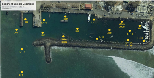
- The Department of Land and Natural Resources (DLNR) collected 20 sediment samples from 17 sites at the Lahaina Small Boat Harbor on November 16, 2023. The fires burned vessels and boats in the Harbor, which may have released harmful substances and debris into nearby water and sediment. The primary purpose of the sampling was to determine whether it would be safe to dispose of sediment in upland areas. Samples were collected from sediment depths ranging from approximately 0.5 to 4 feet below the sea floor.
- U.S. Geological Survey (USGS) sampled numerous locations for a wide range of substances, including potentially fire-related substances. While the data provide context, they are preliminary and not suitable for decision-making. The USGS samples were not collected using DOH protocols for assessment of health risk and cannot be used to assess potential health risks. Nonetheless, the data do not suggest potentially significant health concerns.
Understanding the Coastal Sediment Data
DOH Data
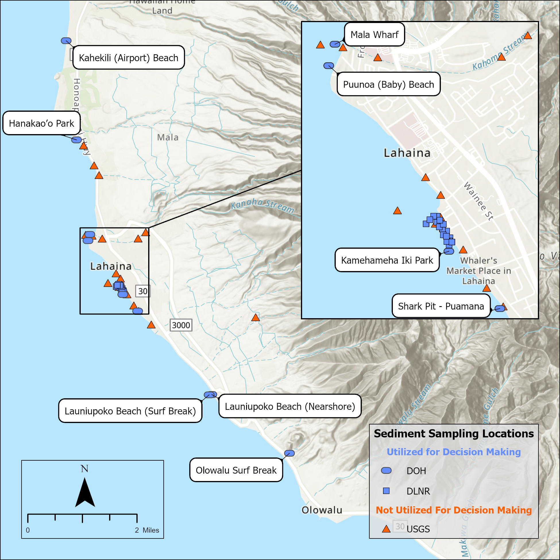
DOH and partners continue to collect sediment samples in the nearshore areas of Lahaina. Sampling began in May 2024, and the most recent sampling event occurred in February 2026. Samples are collected in accordance with DOH protocols and procedures; these data have been validated to support public health decision-making. DOH collected samples from multiple locations (Figure 1). The Kahekili (Airport) Beach site is a reference site for data comparability. Kahekili Beach nearshore sediment is not expected to show impacts from the wildfires and DOH can compare the sediment from Kahekili to sediment from other locations to understand fire-related effects.
Figure 2 presents a summary of the results from coastal sediment sampling occurring from May 2024 through February 2026. The samples were analyzed for various metals that may be present in the coastal sediment based on the results of ash sampling data from the Lahaina fires. Figure 2 also presents DOH’s Environmental Action Levels (EALs) developed for contact with soil to serve as an initial screening tool to assess possible human health effects. For select sites, multiple samples were collected for quality assurance purposes. To view results from sites with replicates interactively in the figures (duplicates and triplicates), hover over the figure to open the pop-ups.
These results show that measured levels of metals are at or below DOH health-based screening levels. It is important to note that DOH screening values are based on the exposure of people to soil and assume much more contact than would be expected for coastal sediment. Therefore, the reported levels do not pose a significant health concern for the minimal contact expected with these sediments.
Sediment Metals Concentrations
Figure 2. Interactive time series of nearshore sediment sample results collected by DOH from May 2024 through February 2026. Hover over the points to see results in a pop-up.
Note that volcanic soils on Maui have naturally high levels of metals in comparison to typical soils on the mainland United States, including aluminum, iron, manganese, and titanium. These naturally occurring metals could affect the levels of metals in sediment but are tightly bound to minerals in the soil and do not pose a health risk to residents or aquatic habitats. The Hawaiian Islands Soil Metal Background Evaluation Report – 2012 (PDF, opens in a new tab) includes information on background concentrations of metals in Hawaii sediments.
DLNR Data
DNLR collected sediment samples from 17 sites at the Harbor on November 16, 2023 (Figure 3).
The samples were analyzed for more than 85 parameters, including metals, total petroleum hydrocarbons-diesel range organics (TPH-DRO), dioxins, and others. Table 1 presents a subset of the results, with a focus on fire-related substances of potential concern (substances known to stick to wildfire dust and ash) at sampling locations.
As shown in Table 1, reported levels are below DOH’s commercial/industrial EALs for direct soil exposure. The results of the initial screening indicate that sediments could be dredged and may be suitable for upland disposal and reuse at commercial or industrial sites as fill material or daily landfill cover. However, additional sampling and analysis are needed to evaluate final suitability decisions for sediment reuse.
| Parameters | DOH EAL: Commercial/ Industrial Direct Exposure1 | LH3 | LH4 | LH6 | LH7a | LH8 | LH9a | LH11 | LH12a | LH13 | LH16 | LH17 | ||||||||||||
|---|---|---|---|---|---|---|---|---|---|---|---|---|---|---|---|---|---|---|---|---|---|---|---|---|
| Arsenic | 95 | 28 | 25.6 | 29.4 | 21.8 | 17.0 | 19.4 | 17.3 | 16.5 | 14.8 | 16.2 | 27.7 | ||||||||||||
| Copper | 2500 | 39.5 | 30.3 | 24.1 | 259 | 2,290 | 1,370 | 716 | 1,680 | 693 | 1,170 | 37.2 | ||||||||||||
| Lead | 800 | 8.35 | 8.61 | 7.98 | 29.7 | 68.5 | 40.1 | 45.6 | 42.4 | 40.1 | 141 | 6.32 | ||||||||||||
| TPH-DRO | 680 | 9.3 | 19.2 | 7.36 | 387 | 31.1 | 117 | 129 | 114 | 121 | 9.31 | 232 | ||||||||||||
| Dioxins (Total) | — | 0.000498 | 0.000738 | 7.71E-05 | 0.00048 | 0.00116 | 0.00245 | 0.00189 | 0.00248 | 0.00986 | 0.0026 | 5.33E-05 | ||||||||||||
| TEQ - Dioxins | 0.0015 | 7.64E-07 | 1.37E-06 | 3.51E-07 | 2.3E-05 | 3.2E-05 | 1.6E-05 | 1.5E-05 | 2.6E-05 | 2.8E-05 | 7.56E-06 | 2.16E-06 | ||||||||||||
| Acenaphthylene | 5.5 | 0.0012 | ND | ND | 0.067 | 0.075 | 0.018 | 0.017 | 0.027 | 0.023 | ND | 0.044 | ||||||||||||
| Acenaphthene | 120 | ND | ND | ND | 0.027 | 0.013 | 0.0054 | 0.0048 | ND | 0.0059 | ND | 0.018 | ||||||||||||
| Anthracene | 4.2 | ND | 0.0046 | ND | 0.073 | 0.13 | 0.015 | 0.0089 | 0.028 | 0.016 | ND | 0.033 | ||||||||||||
| Benzo[a]anthracene | 10 | 0.0080 | ND | 0.015 | 0.071 | 0.055 | 0.025 | 0.03 | 0.047 | 0.043 | 0.0036 | 0.025 | ||||||||||||
| Benzo[a]pyrene | 5.9 | 0.0045 | ND | 0.0093 | 0.055 | 0.037 | 0.017 | 0.027 | 0.034 | 0.041 | ND | 0.016 | ||||||||||||
| Benzo[b]fluoranthene | 68 | 0.0060 | ND | 0.014 | 0.098 | 0.084 | 0.037 | 0.040 | 0.041 | 0.063 | ND | 0.031 | ||||||||||||
| Benzo[g,h,i]perylene | 35 | 0.0033 | ND | 0.0077 | 0.039 | 0.035 | 0.025 | 0.031 | 0.034 | 0.047 | ND | 0.017 | ||||||||||||
| Benzo[k]fluoranthene | 39 | 0.0029 | ND | 0.0059 | 0.018 | 0.015 | 0.011 | 0.014 | 0.015 | 0.022 | ND | 0.0077 | ||||||||||||
| Chrysene | 30 | 0.0054 | ND | 0.014 | 0.094 | 0.076 | 0.032 | 0.029 | 0.051 | 0.045 | ND | 0.027 | ||||||||||||
| Dibenz[a,h]anthracene | 18 | 0.0016 | ND | 0.0038 | 0.013 | 0.016 | 0.0036 | 0.0066 | 0.0077 | 0.0097 | ND | 0.0031 | ||||||||||||
| Fluoranthene | 87 | 0.0083 | 0.007 | 0.021 | 0.12 | 0.10 | 0.074 | 0.057 | 0.085 | 0.094 | ND | 0.087 | ||||||||||||
| Fluorene | 93 | ND | ND | ND | 0.074 | 0.076 | 0.0087 | 0.0063 | 0.019 | ND | ND | ND | ||||||||||||
| Indeno[1,2,3-cd]pyrene | 31 | 0.0028 | ND | 0.0077 | 0.031 | 0.033 | 0.013 | 0.023 | 0.029 | 0.036 | ND | 0.01 | ||||||||||||
| 1-Methylnaphthalene | 0.89 | 0.0015 | ND | 0.0011 | 0.066 | 0.072 | 0.012 | 0.0080 | 0.020 | 0.012 | ND | 0.017 | ||||||||||||
| 2-Methylnaphthalene | 1.9 | 0.0024 | ND | 0.0017 | 0.08 | 0.091 | 0.027 | 0.018 | 0.029 | 0.027 | ND | 0.029 | ||||||||||||
| Naphthalene | 3.1 | 0.0077 | ND | 0.0054 | 0.29 | 0.36 | 0.12 | 0.13 | 0.14 | 0.15 | 0.0033 | 0.16 | ||||||||||||
| Phenanthrene | 69 | 0.0068 | 0.0047 | 0.012 | 0.27 | 0.32 | 0.067 | 0.044 | 0.097 | 0.068 | ND | 0.13 | ||||||||||||
| Pyrene | 44 | 0.0088 | 0.0065 | 0.02 | 0.19 | 0.12 | 0.10 | 0.07 | 0.095 | 0.11 | ND | 0.14 | ||||||||||||
Sediment data provided by DLNR.
DOH EAL: Hawaii DOH Environmental Action Level for screening. An entry of “—” means the analyte does not have an EAL.
TPH-DRO: Total petroleum hydrocarbons – diesel range organics
ND: Non-detect
TEQ Dioxins: “Toxic equivalent concentration” that allows the reporting of multiple dioxin/dioxin-like chemicals as a single value based on their relative toxicities.
1Screening values represent soil EALs for commercial/industrial land use obtained from DOH’s TGM EAL Surfer (Tier 1 EALs) search function (found here: Environmental Hazard Evaluation and Environmental Action Levels – HEER Office (hawaii.gov) (opens in a new tab)) at the time of data release (December 2023).
USGS Data
USGS conducted land-based and nearshore sediment sampling between September 2023 and February 2024. The focus was on sediment collected from “marine,” “marine (beach),” and “terrestrial” areas, as labeled by USGS, including grab samples of sediment from the Harbor. The samples were not collected in a manner that allows direct comparison to DOH EALs and are useful for qualitative purposes only (Tables 2, 3, and 4).
| Parameters | Offshore Kahoma Stream | Offshore Lahaina Harbor | Inshore Ferry Dock | Inshore Lahaina Harbor | Offshore Kahoma Stream | Offshore Lahaina Harbor | Inshore Lahaina Harbor | Inshore Ferry Dock | ||||||||
|---|---|---|---|---|---|---|---|---|---|---|---|---|---|---|---|---|
| Antimony | 0.4 | 0.5 | 5.9 | 24.4 | 0.4 | 0.7 | 1.4 | 16 | ||||||||
| Arsenic | 5 | 15 | 43 | 75 | 9 | 11 | 18 | 46 | ||||||||
| Chromium | 1292 | 2553 | 551 | 562 | 1960 | 1275 | 420 | 424 | ||||||||
| Cobalt | 52.4 | 72.3 | 39.3 | 35.2 | 62.7 | 55.2 | 37.8 | 32.2 | ||||||||
| Copper | 108 | 124 | 309 | 670 | 135 | 101 | 173 | 1496 | ||||||||
| Lead | 10 | 8 | 64 | 176 | 7 | 19 | 44 | 110 | ||||||||
| Nickel | 232 | 285 | 134 | 111 | 277 | 233 | 144 | 114 | ||||||||
| Vanadium | 429 | 538 | 244 | 193 | 542 | 412 | 279 | 200 | ||||||||
| Zinc | 146 | 187 | 421 | 2018 | 184 | 194 | 226 | 740 | ||||||||
| TEQ Dioxins | 1.20E-07 | 2.65E-08 | 5.15E-06 | 2.01E-05 | 5.99E-08 | 5.56E-08 | 6.51E-07 | 3.33E-05 | ||||||||
| Acenaphthene | — | — | — | — | ND | ND | ND | ND | ||||||||
| Acenaphthylene | — | — | — | — | ND | ND | ND | ND | ||||||||
| Anthracene | — | — | — | — | ND | ND | ND | ND | ||||||||
| Benzo(a)anthracene | — | — | — | — | ND | ND | ND | ND | ||||||||
| Benzo(a)pyrene | — | — | — | — | ND | ND | ND | ND | ||||||||
| Chrysene | — | — | — | — | ND | ND | ND | ND | ||||||||
| Dibenzo(a,h)anthracene | — | — | — | — | ND | ND | ND | ND | ||||||||
| Fluoranthene | — | — | — | — | ND | ND | ND | ND | ||||||||
| Fluorene | — | — | — | — | ND | ND | ND | ND | ||||||||
| Naphthalene | — | — | — | — | ND | ND | ND | ND | ||||||||
| Phenanthrene | — | — | — | — | ND | ND | ND | ND | ||||||||
| Pyrene | — | — | — | — | ND | ND | ND | ND | ||||||||
Grab sample sediment data provided by USGS; sampling locations are listed as presented by USGS as “marine sediment.”
An entry of “—” means the analyte does not have an EAL.
Data are provisional and not suitable for decision-making.
ND: Non-detect
TEQ Dioxins: “Toxic equivalent concentration” that allows the reporting of multiple dioxin/dioxin-like chemicals as a single value based on their relative toxicities.
| Parameters | Turtle Rock | Hanakao'o Beach Park | Front Street 505 | Mala Boat Ramp | Kahoma Stream Lower Reach | Outfall K (pipe, boat) | Outfall O (box, ash) | Outfall R (sandy, with fish) | ||||||||
|---|---|---|---|---|---|---|---|---|---|---|---|---|---|---|---|---|
| Antimony | 0.1 | 0.2 | 0.2 | 0.2 | 0.8 | 15.8 | 1 | 1.5 | ||||||||
| Arsenic | 10 | 9 | 10 | ND | ND | 93 | 7 | 26 | ||||||||
| Chromium | — | — | — | — | 900 | 670 | 24718 | 633 | ||||||||
| Cobalt | — | — | — | — | 65.9 | 36.5 | 102 | 50.3 | ||||||||
| Copper | 27 | 28 | 32 | 65 | 148 | 810 | 126 | 103 | ||||||||
| Lead | ND | 12 | ND | ND | 9 | 1047 | 24 | 31 | ||||||||
| Nickel | — | — | — | — | 345 | 157 | 768 | 218 | ||||||||
| Vanadium | — | — | — | — | 418 | 220 | 926 | 292 | ||||||||
| Zinc | 53 | 70 | 66 | 83 | 186 | 1088 | 332 | 519 | ||||||||
| TEQ Dioxins | — | — | — | — | 9.84E-08 | 1.79E-06 | 3.04E-08 | 1.16E-07 | ||||||||
| Acenaphthene | — | — | — | — | — | 0.0546 | ND | ND | ||||||||
| Acenaphthylene | — | — | — | — | — | ND | ND | ND | ||||||||
| Anthracene | — | — | — | — | — | ND | ND | ND | ||||||||
| Benzo(a)anthracene | — | — | — | — | — | 0.0361 | ND | ND | ||||||||
| Benzo(a)pyrene | — | — | — | — | — | 0.0286 | ND | ND | ||||||||
| Chrysene | — | — | — | — | — | 0.0278 | ND | ND | ||||||||
| Dibenzo(a,h)anthracene | — | — | — | — | — | ND | ND | ND | ||||||||
| Fluoranthene | — | — | — | — | — | 0.118 | ND | ND | ||||||||
| Fluorene | — | — | — | — | — | ND | ND | ND | ||||||||
| Naphthalene | — | — | — | — | — | ND | ND | ND | ||||||||
| Phenanthrene | — | — | — | — | — | 0.0887 | ND | ND | ||||||||
| Pyrene | — | — | — | — | — | 0.0574 | ND | ND | ||||||||
Grab sample sediment data provided by USGS; sampling locations are listed as presented by USGS as “marine beach.”
An entry of “—” means the analyte does not have an EAL.
Data are provisional and not suitable for decision-making.
ND: Non-detect
TEQ Dioxins: “Toxic equivalent concentration” that allows the reporting of multiple dioxin/dioxin-like chemicals as a single value based on their relative toxicities.
| Parameters | Pualea Loop | Kahoma Stream Retention Basin | Wahikuli Culvert | Outfall I (Storm Drain) | Outfall J (Runoff Behind Silt Sock) | Kahoma Stream Bank Runoff | ||||||
|---|---|---|---|---|---|---|---|---|---|---|---|---|
| Antimony | ND | 0.4 | 0.5 | 6.6 | 9.5 | 0.3 | ||||||
| Arsenic | ND | ND | 10 | 38 | 75 | ND | ||||||
| Chromium | — | 410 | 233 | 714 | 953 | 1193 | ||||||
| Cobalt | — | 53.6 | 69.5 | 52.1 | 50.8 | 81.6 | ||||||
| Copper | 131 | 129 | 165 | 317 | 565 | 163 | ||||||
| Lead | ND | 7 | 6 | 158 | 51 | 6 | ||||||
| Nickel | — | 240 | 163 | 223 | 184 | 403 | ||||||
| Vanadium | — | 389 | 358 | 316 | 281 | 485 | ||||||
| Zinc | 130 | 172 | 155 | 760 | 1696 | 176 | ||||||
| TEQ Dioxins | — | 1.14E-06 | 4.40E-06 | 0.0004 | 9.14E-05 | 1.12E-05 | ||||||
| Acenaphthene | — | — | ND | ND | ND | ND | ||||||
| Acenaphthylene | — | — | ND | ND | ND | ND | ||||||
| Anthracene | — | — | ND | ND | ND | ND | ||||||
| Benzo(a)anthracene | — | — | ND | ND | ND | ND | ||||||
| Benzo(a)pyrene | — | — | ND | ND | ND | ND | ||||||
| Chrysene | — | — | ND | ND | ND | ND | ||||||
| Dibenzo(a,h)anthracene | — | — | ND | ND | ND | ND | ||||||
| Fluoranthene | — | — | ND | ND | ND | ND | ||||||
| Fluorene | — | — | ND | ND | ND | ND | ||||||
| Naphthalene | — | — | ND | ND | ND | ND | ||||||
| Phenanthrene | — | — | ND | ND | ND | ND | ||||||
| Pyrene | — | — | ND | ND | ND | ND | ||||||
Grab sample sediment data provided by USGS; sampling locations are listed as presented by USGS as “marine beach.”
An entry of “—” means the analyte does not have an EAL.
Data are provisional and not suitable for decision-making.
ND: Non-detect
TEQ Dioxins: “Toxic equivalent concentration” that allows the reporting of multiple dioxin/dioxin-like chemicals as a single value based on their relative toxicities.
Air | Ash and Debris | Beach Sand | Coastal Sediment | Coastal Waters | West Maui TDS Site | Coral Reef Health | Drinking Water | Fish | Soil | Wastewater